|
|
Finding Latitude and Longitude with GPS - How GPS works
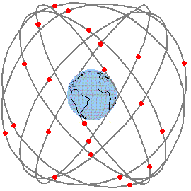
There is a constellation of at least 24 GPS satellite in orbit around the earth. Each orbit takes 11 hours 58 minutes to complete and inclination and positioning of the satellites around the orbits is arranged so that wherever you are there should be several satellites visible in the sky above you. The satellites are about 20200 km high, a little less than half the height of the 24 hour orbits of the geostationary satellite. The number of operational satellites varies as older ones are retired and new ones are launched, but is typically in the range 24 to 30 in orbit at any time.
Each GPS satellite broadcasts a high power, narrow bandwidth, downlink signal that may be received on your small hand held receiver antenna.
Your receiver receives signals simultaneously from all the visible satellites. The downlink frequency is in L band at 1575.42 MHz and comprises a signal intended for public use called the coarse/acquisition code or C/A-code. Another signal is used by military receivers to achieve higher precision latitude-longitude positioning results.
Each satellite has an on-board timing clock (using cesium or rubidium atomic standards) so that it knows what is the time to very high precision and it is able then to transmit signals down at exactly known instants. The signals come down to your receiver at the speed of light ( 300,000 kilometres per second or 300 metres per micro-second ) and the time of arrival of the signals at your receiver is what matters. A computer program in your receiver notes the time of arrival of the signals received from the various visible GPS satellites and is able to work out your latitude and longitude position and also your height. If your position is changing, by observing the changes it is possible to work out the speed of your movement and the direction in which you are moving.
The system needs at least 3 satellite to obtain a latitude and longitude fix. Four satellites allows your height to be determined as well and the more satellites that can be received, this higher the accuracy of the results. The accuracy varies according to the location of the satellites. If four satellites were visible but all close together in the sky then the accuracy would be worse then is they were spaced out widely across the sky. Many GPS receivers have an optional display that shows where the satellite are, like overhead, towards the east or west etc. If you keep the receiver still, it will average readings over a long time to improve the accuracy.
Accuracy depends on several factors:
Tropospheric delays: The amount of moisture in the atmosphere slows down the signals slightly, particularly if they arrive from a satellite just above the horizon and uncertainty in this degrades the accuracy of the timing calculation.
Orbit ephemeris data accuracy: The satellites each have on board some data which describes their orbital parameter (orbit ephemeris figures) and they broadcast this data to your receiver so that your receiver can work out where the satellite was when it transmitted. The orbit ephemeris are updated frequently using ground based measurements, but any errors will affect the positioning results.
Multi-path reflection: Sometimes there are nearby buildings reflections will affect the accuracy. If you are in a road with tall buildings either side signal may arrive at your receiver via reflections.
Deliberate errors: Because accurate location information is of military significance, the accuracy of the publicly available system may be degraded or even turned off. In the early days of GPS, the public system always had moderate errors. This was called Selective Availability. Selective Availability was turned off in May 2000 to allow soldiers using shop bought GPS receiver to achieve their required accuracy and the system has be left in this mode since.
Extremely high accuracy latitude-longitude positioning is possible if you use differential GPS. In this case you need two receivers. You fix one receiver precisely and call this your reference location, for example at the corner of a field. At this reference receiver you make a record of the long term average (accurate) location and also the instantaneously displayed location (less accurate) and note the differences. You then broadcast locally (using a radio) the differences, which will vary second by second due to atmospheric effects etc. You then move the other receiver around locally together with a receiver of your differential correction data and add or subtract the differences from the readings observed. Differential GPS was of great benefit before May 2000, while Selective Availability was applied.
|
► Page created 15th April 2006, amended 2 March 2022, 27 March 2026. All pages on this satsig.net web site are Copyright Satellite Signals Limited © 2005 all rights reserved. |