Instructions :
When started up this web page should display a static image based on the default longitude. Longitude east is positive. See my explanation of latitude and longitude.
The default viewing longitude is 55.5 deg West, presently corresponding to the INTELSAT 34 satellite.
This page is not intended for use on small screen devices. The canvas picture image above may be copied to your PC using right mouse click and "Save image" as or "Copy Image".
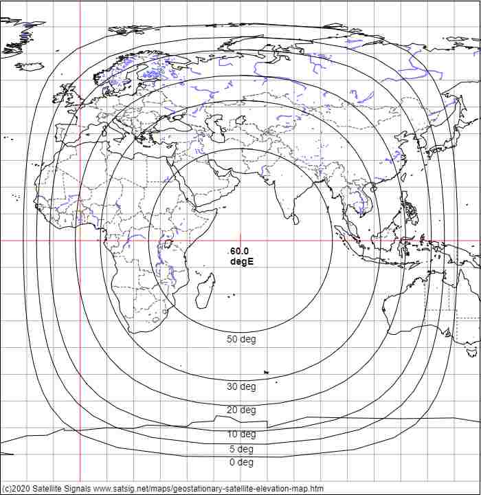
This is an example image output showing the elevation angle contours for a satellite at 60 deg east longitude above the Indian Ocean Region.
The elevation angles used in the above maps have been calculated assuming a straight line between you and the satellite. At low elevation angles the atmosphere, which is denser lower down, causes refraction which bends the line downwards, so on the 5 deg or 0 deg lines above you will likely find the satellite appears a bit higher up. The signal level and angle of arrival will vary due to scintillation caused by layers of air with different densities, moisture content and temperature. My recommended minimum operational elevation angles are 5 deg at C band and 15 deg at Ku band.
I have added the 70 deg elevation contour on 31 May 2020.
Map data used in the above is from the GSHHG v2.3.5 (Global Self-consistent, Hierarchical, High-resolution Geography Database), available from NOAA, a U.S. government agency.
Copyright notice: As of GSHHG 2.2.2, GSHHG is distributed under the GNU Lesser General Public License (LGPL) version 3 or later. Copies of the The GNU General Public License (GPL) and the GNU Lesser General Public License (LGPL) are distributed along with the sources. Permission to use, copy, modify, and distribute (with no more than a reasonable redistribution fee) this data and its documentation for any purpose is hereby granted, provided that the above copyright notice appear in all copies, that both that copyright notice and this permission notice appear in supporting documentation, and that the name of GSHHG not be used in advertising or publicity pertaining to distribution of the software without specific, written prior permission. The University of Hawaii (UH) and the National Oceanic and Atmospheric Administration (NOAA) make no representations about the suitability of this software for any purpose. It is provided "as is" without expressed or implied warranty. It is provided with no support and without obligation on the part of UH or NOAA, to assist in its use, correction, modification, or enhancement. The information must not be used for navigational purposes.
Page created 22 May 2020, last amended 31 May 2020, 12 May 2026. Eric Johnston
All pages on this satsig.net web site are Copyright Satellite Signals Limited © 2020 all rights reserved.