Satellite view of the earth from geostationary orbit position at 97 deg west longitude
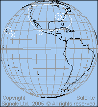
Example C band beam coverage (INTELSAT AMERICAS 5 - TELSTAR 5 ) at 97 deg west longitude above the eqator.
The C band beam EIRP contour coverage, with downlink power in dBW, with 3 dB steps. Note that the white outline beam contours are the direct view from the satellite. When the satellite antenna is tested on the ground, prior to launch, this is what the beams would look like. The angular diameter of the earth is about 17 deg.
Approx C band (4 GHz) receive earth station dish sizes required: 39 dBW = 2m. 36 dBW = 2.8m. 33 dBW =4m.
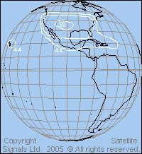
Example Ku band beamINTELSAT AMERICAS 5 ( TELSTAR 5 ) at 97 deg west longitude
Ku band coverage with EIRP for the downlink transponders. If the spot beam over Hawaii is 0.5 deg diameter (at the -3dB points), what size satellite antennas are required for 14 GHz (uplink) and 11 GHz downlink ? Use this Satellite antenna beamwidth calculator find the answer.
Approx receive earth station dish sizes required for various satellite EIRP per TV carrier 50 dBW = 85cm 47 dBW = 1.2m 44 dBW =1.8m
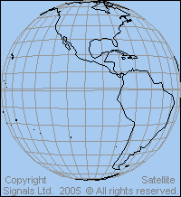
This is the blank view of the earth from 35786km above 97 deg west longitude. Print out and you have the chance to draw on this a circular, elliptical or shaped beam as you wish to suit you desired coverage area, for example a South America country.
Try first by drawing a circle over your desired country. Measure the diameter (mm) and find its diameter in degrees by reference to the 17 deg diameter of the visible earth view. Then, for 4, 6, 11 and 14 GHz, determine to gain and spacecraft dish diameter needed on the satellite. You can read more about doing this here: Satellite views from geostationary height.
|
► Page created 26 Sept 2005, amended 8 June 2021, 9 June 2021, 10 May 2026. All pages on this satsig.net web site are Copyright Satellite Signals Limited (c) 2005 all rights reserved. |