Instructions to create your own rotating globe:
When started up this web page should display a static image based on the default viewpoint height and latitude and longitude. Latitude north is positive. Longitude east is positive. See my explanation of latitude and longitude.
Try some of the Ideas buttons so you get a feel for what can be done. Then try inputting your own choice of viewpoint location and height. In you are in South America, such as Brazil, your location will be something like -20 deg south latitude and -50 west longitude. Input those numbers and click Draw the view.
The views of the earth from space are intended for amusement and educational purposes only. I make no claims for accuracy!. Use the Start and Stop buttons to show the animated version representing the daily rotation of the earth on its polar axis. The sun rises in the East, so the surface of the earth is shown moving eastwards.
Students designing or contemplating satellite communications systems design might use views of the globe as seen from 35768km above the equator for geostationary satellites, or from lower orbits elsewhere such as for low (LEO) and medium (MEO) orbit satellites in inclined and polar orbits. Consider your required coverage areas (country or countries) and available orbital positions. I have not yet got round to programming in the code to display the coverage maps for spot beams from orbit positions.
How it works:
The images that you see above are not downloaded from the internet but are created in your own browser such as "Chrome" on your PC or tablet device. This has only become possible with browsers that support HTML5 which allows javascript text commands as part of web pages to cause graphics images to be built up on the users screen display. There may be a speed problem with slower devices. Initially it was taking me some 40 seconds of CPU time to generate each first image till I discovered a faster way of loading the coastline, lakes, rivers and political boundary data.
Once you have an image displayed you may do right mouse click and do Save image as or Copy image. Saving will allow you to save the image somewhere on your PC. Copy will put the picture in your clipboard. If you then open a graphics program, like Microsoft Paint, you can do Paste. Saving the image it will be named by default "download.png". You are welcome to resave the images into .gif format in readiness for making an animated gif video of the rotating planet earth! If you do this please send me a copy to use here.
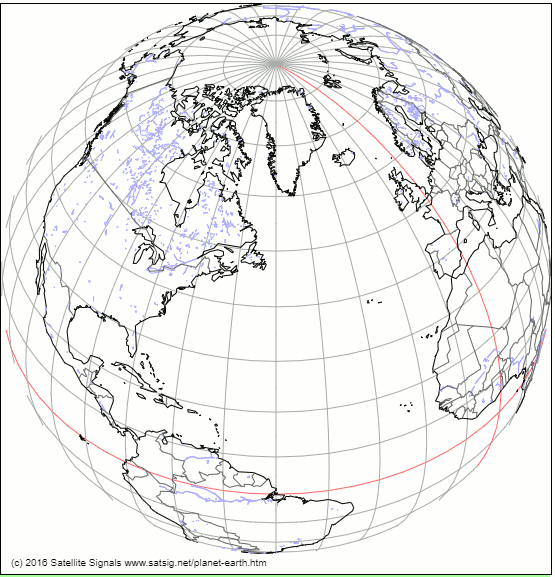
This is an example single frame image of the spinning earth globe.
Please note that the image is not downloaded from the satsig server but is by created locally in your device.
The map data is based on data from NOAA, a U.S. government agency, and is used with permission under GNU Lesser General Public License. See the copyright notice and references at the bottom of this page. I have simplified, reduced the accuracy and adjusted and modified the data manually so please don't be upset if your location is not showing, is in the wrong place or political boundaries are wrong. Remember the outlines are simply supposed to be illustrative. Don't try using the data for navigation purposes unless you are Capt Kirk of the Starship Enterprise.
You are welcome to send to me eric@satsig.net coastline amendments with a series of long/lat pairs referring to your bit of new coastline or whatever. Constructive feedback is also welcome regarding this page and what could be done to improve it.
Global earth rotating image software project.
Many years ago (2005-2005) I wrote a program to do something similar to the above to generate static images from any height and latitude and longitude. This program ran on a SUN Sparc machine under my desk and responded to a web page html image request, with trailing parameters of the requested height and lat/long. The software program returned a gif image view of the world. The coastline data was very basic and not suitable for displaying other than as a small image like the example shown below. No islands, lakes or political boundaries were included.

This view was of the view of the earth is as seen from a geostationary satellite at 35768km above the equator at 0 deg longitude. The view of the earth is approx 17 deg diameter and nearly one third of the earth is visible. Three such satellites, at 120 deg longitude intervals around the equator, can produce global coverage, except for extreme polar regions. I made a number of images saved here: Geostationary orbit views of the earth
One enterprising person ran my program many times for a series of viewpoints along the inclined polar orbit of radio broadcast satellite and then joined all the .gif images together in an animated gif to produce an animated view of the earth as seen from the satellite.
Testing and feedback from users:
I have tested this page on a Windows 10 desktop PC using Chrome, Edge and Firefox browsers and it works OK.
On Android Samsung Galaxy S3 mini I have success with the Chrome browser, there are problems with the native Samsung browser called "Internet" with the blue earth icon. The earth sometimes rotates backwards and the initial map outline is not erased when the animation is started. Any ideas about this welcome.
Apple iMac desktop: OS X Safari works OK.
22 Nov 2016: Just tried Windows 7 and Internet Explorer at the library. The animation does not work. Any ideas please ?
25 Aug 2019: In response to a visitor request I have made it possible to have views of the earth with the coasts, waterways and political boundaries in clear black and white. I have also taken the opportunity to fix a bug that caused a spurious straight line to appear going approx 45 deg NE from 80 deg south, zero longitude.
I would be interested in feedback from users attempting to use small screens of having browser specific problems. To eric@satsig.net please..
Map data used in the above is from the GSHHG v2.3.5 (Global Self-consistent, Hierarchical, High-resolution Geography Database), available from NOAA, a U.S. government agency.
Copyright notice: As of GSHHG 2.2.2, GSHHG is distributed under the GNU Lesser General Public License (LGPL) version 3 or later. Copies of the The GNU General Public License (GPL) and the GNU Lesser General Public License (LGPL) are distributed along with the sources. Permission to use, copy, modify, and distribute (with no more than a reasonable redistribution fee) this data and its documentation for any purpose is hereby granted, provided that the above copyright notice appear in all copies, that both that copyright notice and this permission notice appear in supporting documentation, and that the name of GSHHG not be used in advertising or publicity pertaining to distribution of the software without specific, written prior permission. The University of Hawaii (UH) and the National Oceanic and Atmospheric Administration (NOAA) make no representations about the suitability of this software for any purpose. It is provided "as is" without expressed or implied warranty. It is provided with no support and without obligation on the part of UH or NOAA, to assist in its use, correction, modification, or enhancement. The information must not be used for navigational purposes.
► Page created 25 Oct 2016, last amended 24 Feb 2023, 12 May 2026.
All pages on this satsig.net web site are Copyright Satellite Signals Limited © 2016 all rights reserved.