|
May 16th, 2014 at 12:19pm
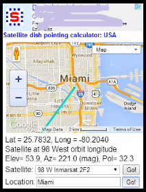
As it looks for me now, using Chrome, Tools, Developer tools, Emulation, Screen 363 pixels wide.
When working on small screen device the following is the intended functionality.
1. Satellite pull down menu: You should be able to select any orbit longitude position.
2. Satellite pull down menu: Go button: When touched once the blue azimuth line on the map should move and the calculated results change. Previously you had to move the map slightly to get it to redraw and recalculate.
3. Your site ZIPcode/town name box: Go button : When touched once this should reposition the map with you at the centre. Previously you sometimes needed to touch the Go button twice to make anything happen.
Feed back on these three aspects would be appreciated.
The next idea suggested is to try and use any GPS in your phone to initially auto centre the map.
|