|
Explanation feed polarisation angle |
Explanation of Latitude and Longitude
Latitude and Longitude are how your site location is defined on the surface of the earth

Click here to find your latitude and longitude
Latitude
Latitude is used to express how far north or south you are, relative to the equator. If you are on the equator your latitude is zero. If you are near the north pole your latitude is nearly 90 degrees north. If you are near the south pole your latitude is almost 90 degrees south.
Conventionally latitude is expressed as degrees north or south. For inputting to the satellite dish pointing calculator, south latitude figures need to be input as negative numbers.
Note that from small regions around the north or south poles you cannot see geostationary satellites at all. The geostationary satellites are below the horizon and directly above the equator, in a circle all around.
Longitude
Longitude shows your location in an east-west direction, relative to the Greenwich meridian. Places to the east of Greenwich (such as Middle East, India, Japan, Australia and New Zealand) have longitude angles up to 180 degrees east. Places to the west of Greenwich (such as the Atlantic and North and South America) have angles up to 180 deg west. For inputting to the satellite dish pointing calculator, longitude west figures need to be input as negative numbers.
Geostationary satellites are located in orbit directly above the equator and stay in the same place in the sky since they go around the earth at the same angular speed as that of the earth as it rotates. Satellite locations may thus be defined by longitude only. The use of east and west longitudes is popular for public use since the numbers are smaller. Use of degrees east only (0 to +360 deg, going east from Greenwich) however is my preference since the satellites go around this way and it makes sense for the numbers to keep increasing if the satellite moves forwards. Trying to do orbit calculations is bad enough without having numbers that keep switching forwards and backwards. Many satellite operators also use the 0 to +360 deg method, but may additionally provide the "deg west" notation for some output publications.
Decimal and degrees/minutes/seconds notation:
Maps and GPS receivers show latitude and longitude angles. Maps usually show bold lines marked in degrees (whole numbers) plus possibly intermediate lines marked 15, 30, 45 minutes or 10, 20, 30, 40, 50 minutes. GPS receivers typically show degrees plus minutes and decimal fractions of a minute. e.g. 45 : 23.1234 You can normally alter the display options on a GPS using the setup menu.
Each degree can be subdivided into 60 minutes (and each minute into 60 seconds for very high precision).
In cases where the map (or GPS readout) is in degrees and minutes, you need to convert the minutes part to decimal parts of a degree, by dividing the number of minutes by 60, so for example.
50 deg 30 minutes north = 50.5 degrees
45 deg 10 minutes east = 45.1667 degrees
92 deg 45 minutes west = -92.75 degrees
What is my latitude and longitude ?
See satellite view maps for Geostationary orbit views of the earth from all 10 deg longitude positions.
I have made you a degrees, minutes, seconds to decimal degrees calculator if you want to do the calculation online.
A latitude measuring experiment for you to try:
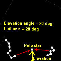
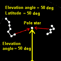
If you are in the northern hemisphere here is an interesting project suggestion. How about determining your latitude yourself by measurement ?.
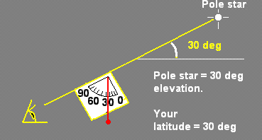
You need to go outside on a clear sky evening and look in a northerly direction and identify the Pole star or Polaris.
This star is in line with the earth's axis and if you measure the elevation angle of the star you determine your latitude.
You need to do two things, first Find the north pole star and, second, Measure its elevation angle.
Read: How to find the pole star
and How to make an inclinometer
Your answer will incorporate a small error, as the pole star is not exactly on the earth's axis line. It is out by by about 0.46 deg. If you watched the position of the pole star for several hours you would see it going in an arc of a tiny circle, about 0.9 deg diameter. It goes round the circle every day and if you knew the time and its position around the circle you could adjust your result to remove the error. The error varies with time, with one maximum of +0.46 deg, one minimum of -0.46 deg and two times, 12 hours apart, with zero error. Alternatively, if you can see the Great Bear you can guess the approximate place to point your inclinometer or sextant using the big star chart lower down this page.
|
Go to maps to see an index page with a listing of all the map pages. Tell me if you want a page made for your country. |
|
|
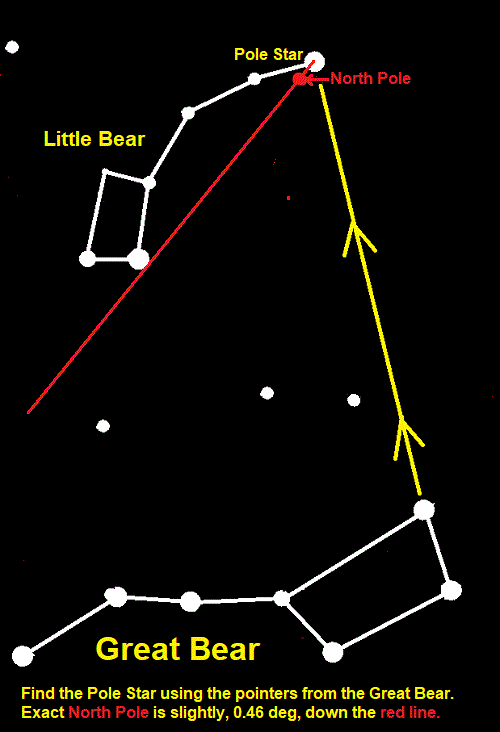
The north pole is 0.46 deg down the red line. This method does not require the time or an almanac.
Some people call the "Great Bear" the "Big Dipper". It is like a pan with a handle!
Advertisement
|
This page started 2005, last amended 25 Feb 2022, 20 Oct 2025. Any problems, please email me, eric@satsig.net All pages on this satsig.net web site are Copyright Satellite Signals Limited (c) 2005 all rights reserved. |