Satellite Internet forum
https://www.satsig.net/cgi-bin/yabb/YaBB.pl
Service Providers >> Satellite Connection in Africa >> HOW TO USE INCLINOMETER AND COMPASS
https://www.satsig.net/cgi-bin/yabb/YaBB.pl?num=1180709646

Message started by obotsam on Jun 1st, 2007 at 3:54pm

Title: HOW TO USE INCLINOMETER AND COMPASS
Post by obotsam on Jun 1st, 2007 at 3:54pm
HI ERIC,
PLS IM HAVING DIFFICULTY MOVING FROM NSS7 SATELLITE TO AMC-12/NSS10 SATELLITE DUE TO THE PROBLEM THAT DEVELOPED IN  MY SPECTRUM ANALYZER. I THOUGHT I COULD USE INCLINOMETER AND COMPASS TO ACHIVE THIS. THE AMC-12/NSS10 IS 37.5 DEGREES AND AZIMUTH IS 267.8 AND WEST WHILE NSS7 IS 22 DEGREES WEST.
HOPE TO GET AN ASIISTANT FROM YOU.
BEST REGARDS,
SAM OBOT.

Title: Re: HOW TO USE INCLINOMETER AND COMPASS
Post by Eric Johnston on Jun 1st, 2007 at 5:15pm
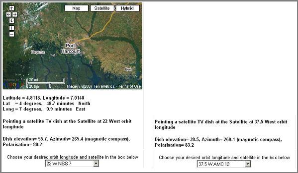
You don't give your location, but based on the azimuth angle of 267.8 deg for AMC12/NSS10 you are somewhere along a line through Aba in Nigeria and Bamenda in Cameroon.  Figures below are illustrative only based on my guesswork.

Your initial dish pointing for NSS7 at 22 W was perhaps:
NSS7   Elevation = 52    Azimuth = 263.8    Pol = 78.9

Your new dish pointing for AMC12/NSS10 at 37.5W is perhaps:
NSS10 Elevation = 35    Azimuth = 267.8    Pol = 82

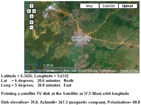
Elevation: to get to the new satellite you need to come down by 52 - 35 =  17 deg.

Azimuth: the new satellite is 267.8 - 263.8 = 4 deg to the right.

If you are using linear polarisation and still using the same polarisation on the new satellite then the feed needs turning 82 - 78.9 = 3.1 deg clockwise while facing the satellite.  Note you are near the equator and since your satellite is far to the west, your polarisation adjustment is very large, approaching 90 deg!  

Start by getting the exact pointing details, for your location, for both satellites, then work out the differences and apply them.  

ref: https://www.satsig.net/maps/lat-long-finder.htm
wxw
Best regards, Eric.

Title: Re: HOW TO USE INCLINOMETER AND COMPASS
Post by obotsam on Jun 4th, 2007 at 11:50am
Eric,
Thanks for your good feedback. i forgot to give u the location. The location is inthe heart of town in port harcourt.
Thanks.
Sam

Title: Re: HOW TO USE INCLINOMETER AND COMPASS
Post by Eric Johnston on Jun 4th, 2007 at 1:44pm
From https://www.satsig.net/maps/satellite-dish-pointing-west-africa.htm


Elevation down from 55.7 to 38.5 (down 17.2 deg)
Azimuth 265.4 to 269.1 (3.7 deg to the right)
Polarisation 80.2 to 83.2 ( 3 deg futher clockwise)

Best regards, Eric.

Title: Re: HOW TO USE INCLINOMETER AND COMPASS
Post by esegbue on Jul 20th, 2007 at 12:07pm
Hi Eric,
please am having problem with my site am in benin city nigeria i want to connect to amc-12/nss10 on 37.5w and i have a 1.8mdish 5watt buc please wat will be the elevation, polarization and azimuth
and please how do i take my readings using inclinometer and where to take the readings whether from the back of the dish or at the front
thank you

ESE

Title: Re: HOW TO USE INCLINOMETER AND COMPASS
Post by Forum Admin on Jul 30th, 2007 at 6:53pm
From https://www.satsig.net/maps/satellite-dish-pointing-west-africa.htm

Find Benin City, Nigeria, by dragging the mouse or double clicking.  Calculation results are:


Elevation 39.8 degrees.  Set using the up/down elevation scale on the back of the dish.  If no scale and you know the offset angle of the dish, then set the front of the dish vertical and and the beam elevation will the the same as the offset.  Tilt further backwards to make up a total of 39.8 deg.  If no scale and no understanding of offset then put a thin strip of wood over the top of the feed and under the bottom edge of the dish and adjust till this strip slopes at 39.8 deg (approx).
wxw  
Azimuth  267  A little to the left of due east, (E= 270 deg).

Polarisation 80.8   Start with the feed set for either vertical or horizontal receive polarisation (as told to you by the NOC).  Then turn 80.8 deg clockwise while facing the satellite.

See here on how to use a compass

Best regards, Eric.

Powered by YaBB 2.5.2!
YaBB Forum Software © 2000-. All Rights Reserved.