Advertisment: Broadband via satellite
Advertisment: Worldwide satellite services from Ground Control Company

www.satsig.net

Satellite Internet Forum.

Welcome, Guest.        Forum rules.
      Home            Login            Register          
Pages: 1

Eutelsat W6 from Iraq

(Read 9273 times)
Ex Member
Ex Member


Feb 14th, 2007 at 12:51pm  
Howdy All,
    I am currently stationed in Iraq and have recently purchased a brand new Idirect System from Bentley Walker.  They put me on Eutelsat W6.  I have a 1.2m Andrew Class II dish.  My Lat/Long is 33.52N and 44.25E.  According to three different calculators I found from my location I need an azimuth of 213, elevation of 45, and a polarization of 30.  I have a Lecuna meter with updated software for W6, have aligned my dish to the mentioned settings and cannot find the signal.  I have already checked my dish for flatness and made the neccessary adjustments.  I have also conducted about 30 hours of searching for W6.  I locked onto another satellite at 35 elevation at about 260 degrees azimuth (PQ=95), so I know I do not have an equipment issue.  My search methods are meticulous, settting elevation and slowly sweeping azimuth around 213.  Adjusting up or down by one degree and sweeping again.  Does anybody have any advise at all?  I've got a group of Soldiers who are growing inpatient, and I'm about to kick the dish off the roof myself.  Thanks everybody!
Back to top
 
 
IP Logged
 
Eric Johnston
Senior Member
★★★
Offline


Posts: 2109
Reply #1 - Feb 14th, 2007 at 3:31pm  
1.  The Lacuna meter should give an increase in noise level every time you pass any satellite.   The noise power reading will enable you to peak up on any satellite and any polarisation.

If a particular programmed carrier is being searched for, it will lock up when it finds the right satellite, but ONLY if the polarisation has been set correctly and the LNB LO frequency is the same as that used by the person who programmed the Lacuna.  The Lacuna simply looks for a carrier at an L band (cable) frequency with a particular symbol rate.

In the area of the sky under consideration the satellites are in a sloping line, higher up towards south and lower down towards the west.

Once you have found a satellite, then the others must be either higher up to the left or lower down to the right.   It is helpful to mark the found satellite and then go searching.  You can always go back and start from that position again.   Each time you find a new satellite note its elevation angle exactly.

If you can successfully identify any satellite, then count along the orbit till you come to the corrrect one.  You can also read the elevation scale and then adjust the elevation scale by the respective relative amount and thus target the wanted satellite immediately.  e.g. If you found Eutelsat at 10E (elevation=37.6) and wanted satellite is Eutelsat W6 21.6E (elevation=44.7) then from your intitial position increase the elevation by 7.1 deg.

2.  My calculations: Assuming your location 33 deg 52 min N, 42 deg 25 min E.


Satellite      Elev    Az       Pol
ArabSat 26.2E  46.9    203.5    22.6
EutW6   21.5E  44.7    210.4    28
Astra   19E    43.4    213.5    30.4
Eut W2  16E    41.5    217.7    33.5
HotB    13E    39.6    221.3    36.2
EutW1   10E    37.6    224.7    38.6
EutW3A   7E    35.5    227.9    40.8
NSS7    22W    12.6    251.0    53.3


Not all satellites may have beams towards you so may not be detectable.   Other satellites exist.  Azimuth bearings are magnetic compass and are approximate - any error will be the same for all bearings however.

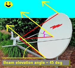
3.  You found something at 35 deg elevation and 260 azimuth.   This pair seems improbable.  I have inserted NSS7 into the satellite list above.  This is at 251 deg azimuth, but only 12 deg elevation.  Are you reading your elevation scale correctly ?   With the front face of the dish vertical the beam elevation will be somewhere around 20 to 30 deg (possibly 22.5 deg).   The scale should read say 22.5 deg.   I don't know what is the tick mark.  It may be a nut, it may be the edge of the metal through the slot etc.   If there are opposite (reversed) scales on either side you need the correct scale.

4.  Polarisation

This may be the whole problem.    Setting polarisation is a two step process.  

First set to the nominal downlink polarisation.   What nominal polarisation have you been told ?   If Horizontal then you need to turn the feed assembly so that the broad faces of the LNB waveguide are on either side.

Second, while facing towards the satellite, rotate the feed asembly 28 deg clockwise (for positive polarisation angles).  An inclinometer put sideways across the BUC helps set this angle accurately.  There is probaly a tiny crude scale on the feed throat clamp.  You can use this to measure the amount of movement required (28 deg) but ignore any +/- signs.

5.  There is a possibility that the Lacuna is pre-set to detect a carrier on the opposite polarisation to your wanted iDirect downlink carrier.   Your iDirect receiver should show green when the wanted carrier is detected.
You can peak up using the iDirect software.
...

Best regards, Eric.
Back to top
« Last Edit: Feb 15th, 2007 at 3:00pm by Admin1 »  
 
IP Logged
 
Ex Member
Ex Member


Reply #2 - Feb 15th, 2007 at 2:43pm  
Howdy
    Thanks for the information.  I am currently locked onto a satellite my meter tells me is Eutelsat W6.  I am set at 36 degrees elevation, roughly 225 degrees azimuth, and 38 polarization.  The metal trailers around me give quite a bit of interferance with a compass.  I am using a current dataset for the Lecuna given to me by Bentley Walker.  I updated the dataset last week.  Bentley Walker's starting polarization position is horizontal, which I started at and then rotated the feed cone clockwise until the signal was peaked, 38.  However, when connected to the modem, no signal is detected.  The Idirect flashes yellow on the RX light.  When I try to use the iSite software to check the signal, it gives me no signal strength (voltage = .3).  The meter is configured for that satellite, and says its locked on.  I'm pretty confused.  This has gone beyond the relm of an Aggie Army LT.  Can't spell lost without LT I've always been told.  Thanks Yall!! 
Luke
Back to top
 
 
IP Logged
 
Admin1
YaBB Admin
★★★★★
Offline


Posts: 1203
Reply #3 - Feb 15th, 2007 at 3:25pm  
The pointing now suggests you have the wrong satellite.     You need to go boldly upwards and to the left across several satellites.   Go up 2 deg, swing to the left to find the next satellite, then repeat several times..

If the wrong satellite has a similar carrier (symbol rate and frequency) as the one you are supposed to find with the Lacuna then it may tell you it is Eutelsat W6 when it is not.

I would move up and left in stages till you get to the satellite that makes the iDirect modem go green.

The polarisation you want is 28 deg, not 38 deg.   If you are peaked now on Eutelsat at 10E, go up 7.1 deg and swing left to find W6 at 22.5E

Then spend ages peaking up.

Best regards, Eric.
Back to top
 
WWW  
IP Logged
 
Ex Member
Ex Member


Reply #4 - Feb 21st, 2007 at 10:02am  
Thank you for all your help.  I have found W6 and am logged on.  Turns out the Lecuna Meter was not working.  I put my settings back to where the calculator estimated and used the dish aligning software from Isite, as well as an analog sound meter.  I found the satellite 20 minutes later.  After finding the sat. I hooked the Lecuna back on and it told me I was still not connected to W6.  Go figure, a brand new piece of technology vs older analog tech. and analog won.  Thanks again for all your help!  I'll recommend this site and forum to anyone interested in Satellite Internet.
Back to top
 
 
IP Logged
 
Admin1
YaBB Admin
★★★★★
Offline


Posts: 1203
Reply #5 - Feb 21st, 2007 at 11:05am  
Contact Lacuna and tell them that their software config did not recognise W6 with your combination of polarisation and LNB LO frequency as used for your iDirect downlink.

Tell them your downlink polarisation and also your LNB Local Oscillator downconverter  frequency (10.0  or 10.6 or 11.3 GHz etc).

The Lacuna recognises digital TV type carriers and there must be one visible with your combination of polarisation and LNB LO frequency for the Lacuna to lock on.

The Lacuna should show a noise power increase on every satellite; this is fine for noting where satellites are and peaking up but it does not tell you which satellite is which.

When they send out a software config they should say:
Which satellite?.  Which polarisation?.  Which LNB LO frequency?.  It would also help for clarity if they gave the name of the carrier, symbol rate and satellite frequency it was looking for.

Best regards, Eric.
Back to top
 
WWW  
IP Logged
 
Pages: 1