Advertisment: Broadband via satellite
Advertisment: Worldwide satellite services from Ground Control Company

www.satsig.net

Satellite Internet Forum.

Welcome, Guest.        Forum rules.
      Home            Login            Register          
Pages: 1

Problems setting up Andrew Dish, locating satelite

(Read 8009 times)
Ex Member
Ex Member


Jun 18th, 2007 at 5:15pm  
Problems connecting idirect Netmodem and Locating W3a satelite, have 1.2m Andrew Dish.


1: I have assembled the dish, Horn, LNB and BUC. I discovered that I was not supplied with enough cabling and got one for replacement am no too sure where to connect on the modem?
2: my location is 12°52'36"S , 40°28'48"E , got an elevation of 47.38° aiming along 106.54 Azimuth. ( Cant  get nothing maybe its the way I setup the dish or LNB or BUC.) Tried using satlook but nothing.
3: I am in the middle of nowhere and need your help. I will attach the pictures of the current setup.
Back to top
 
 
IP Logged
 
Eric Johnston
Senior Member
★★★
Offline


Posts: 2109
Reply #1 - Jun 18th, 2007 at 7:23pm  
Connect just the LNB to the receive input on the modem to start with.  You can then spend time finding the satellite and and optimising the pointing without any danger.

Polarisation setting:

Find out from your service provider what polarisation you have been told to receive.  It will be nominal horizontal or nominal vertical.

If your required polarisation is called nominal vertical then rotate your feed assembly in its throat clamp so that the rectangular input waveguide to the LNB is set so that the broad faces are on top and underneath, like so: ... Note it does not matter if the pin inside the LNB is on the bottom or top; the pin is upright and that is vertical polarisation.  You are now at the polarisation starting position.   It helps to have the feed arm sticking out more or less horizontally at this stage.

Now you need to adjust the polarisation angle to match the satellite. Stand behind the dish and face towards the satellite.  The feed assembly needs rotating (minus) 67.5 deg anticlockwise.   If there is a scale on the feed throat use it to count the degrees, but ignore any 0,90 or + or - signs if they are the other way round.   If you have in inclinometer put it sideways across the BUC or LNB or waveguide and tilt till the bubble is exactly 67.5 deg turned.  Wrapping paper round the throat tube and measuring the length of the paper is another way.  The feed polarisation rotation accuracy needed is 1 deg of better.  You may be asked to adjust this by a mm or so under verbal instruction from the NOC.

Elevation angle

I calculate it as 48.7 deg.  Set this using the scale behind the dish.  Note that the pole must be upright and the head nuts that hold the top down must not be too loose, otherwise the dish will sag down somewhat and the angle reading will be wrong.  If you don't find the satellite on the fisrt swing of the dish (as you should) increase the elevation angle by 1 deg and try again.

Azimuth

Your 106 is quite wrong.  The satellite is at 7 E longitude and you are at 40 deg east longitude so the satellite is to the north west of your site.  I calculate your angle as 300.7 deg bearing magnetic compass.  Approx 60 deg west of due north.  You only need to know this approximately as you can swing the dish boldly sideways to initially find the satellite.

Pretune the modem to the downlink frequency and symbol rate and swing the dish till the RX signal is good.

Having found it spend at least an hour peaking up.  You must get it to the exact centre as the transmit beam is narrower than the receive beam.
wxw
Good luck, Eric.

PS.  I note your location https://www.satsig.net/maps/satellite-tv-dish-pointing-south-africa.htm Smiley  Please email pictures of your equipment and location to eric@satsig.net
Back to top
 
 
IP Logged
 
Ex Member
Ex Member


Reply #2 - Jun 19th, 2007 at 10:20am  
Hello Eric,

Thank you for the advice I found it very useful. My service provider has not sent me anything besides the modem update files, when I use iSite to check for the signal it only goes up to 0.3000- 0.47000v MAX.

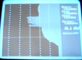
I connected the satlook and the spectrum is 54.0 dBuv at 12520 mhz (the downlink frequency I looked up on the W3A sat table,my service provider says they will send me the option file once I have located the satelite and upgraded the modem.) The satlook is not finding any satelite but the spectrum changes when I move along the azimuth.
I have set it to the best point I could find. (Believing this is where the satellite is.)

Here are the readings off my satlook.
START: 12220 Mhz
STOP : 13391 Mhz
SPAN : 1171 Mhz
Marker 12520

54.0 dBuv

Atten off

My LNB Lo = 11.30Ghz

I have emailed the service provider for the option file also, I cannot find the place to change the downlink  frequency in iSite 7. I still do not know the symbol rate I need to use.

Thank you in advance.
Regards Xami
Back to top
 
 
IP Logged
 
Eric Johnston
Senior Member
★★★
Offline


Posts: 2109
Reply #3 - Jun 19th, 2007 at 11:06am  
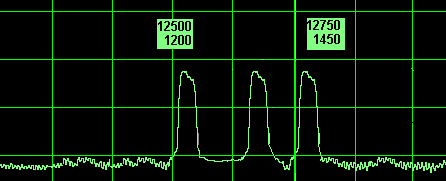
On W3A Ku band Africa beam there are nominal Horizontal polarisation carriers at:
12520 H 27500 1/2
12645 H 30000 1/2
12728 H 30000 3/4

First set your polarisation correctly.  Starting position is with the LNB rectangular waveguide with its broad faces on either side.  This is nominal horizontal polarisation.  Then rotate the feed assembly 67.5 deg anticlockwise, while you are facing towards the satellite.

Your LNB local oscillator is 11.3 GHz so the carrier frequencies in the cable to the modem / satlook are 1220, 1345, 1428 MHz. All are big, about 30 MHz wide.

If your satlook is displaying frequencies like 12520 then these may be quite wrong as they may assume you have a universal satellite TV type LNB with local oscillator frequencies of 9.75 and 10.6 GHz.  Set the satlook to centre frequency 1325 MHz, with span 250,  500 or 1000 MHz.

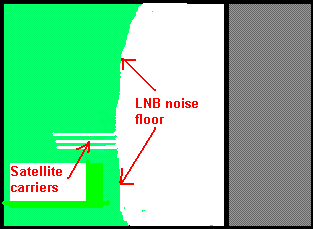
You say the spectrum changes.  What changes ?  You should see something like this:
...
or these (full wide span 950 - 2150 MHz):
... Note this spectrum is just a guesses - not actual.

Best regards, Eric.
Back to top
« Last Edit: Jun 21st, 2007 at 8:33pm by Eric Johnston »  
 
IP Logged
 
Ex Member
Ex Member


Reply #4 - Jun 21st, 2007 at 8:14am  
Dear Eric,
Your calculations are on point. The little spikes were the satelite,I have changed the position of the dish to a tall post and have clear view of the sky.I played around with the elevation and get only around 5.4v on iSite.When I restart iSite I lose signal to 0.3v and I have to swing the dish again to get the signal back. When I checked with the satlook nothing would have changed. I still have not heard anything from my service provider so no option file yet. will 5.4v be sufficient or there  is still something that I am missing.
Thank you again
Regards Xami
Back to top
 
 
IP Logged
 
Eric Johnston
Senior Member
★★★
Offline


Posts: 2109
Reply #5 - Jun 21st, 2007 at 9:11am  
Can you see the three big spikes clearly on the satlook ?  If not, you need to find the satellite.  It is roughly north west, about 30 deg to the right of where the sun sets.  Set the elevation angle accurately with the pole vertical and the azimuth clamp just loose so the dish does not sag down.

Try sending me another picture of the satlook screen.  eric@satsig.net

Having the dish high up on pole is not a good idea for a first time installation.  You need to at least practice at ground level first at a temporary location.  The skill required is high and you have little hope of success working high up.  The rigidity of the pole is also a serious matter.   With an elevation angle of 48.7 deg I hope you will be able to find some temporary ground location with a view of the sky, where you can experiment.

The satlook displays noise power up to 12.  The noise will be from any satellite or the sun or the ground.   It only goes green 12 to 24 once it is locked on to the carrier.  It will not go green unless the modem has been programmed correctly first.

I would prefer you to find W3A using the satlook.  Can you see the three large carriers at the frequencies listed above ?

Best regards, Eric.
Back to top
 
 
IP Logged
 
Eric Johnston
Senior Member
★★★
Offline


Posts: 2109
Reply #6 - Jun 21st, 2007 at 5:32pm  
Does anyone recognise this Ku band satellite as seen from the south east coast of Africa ?

...

Please help.
Best regards, Eric.
Back to top
 
 
IP Logged
 
Ex Member
Ex Member


Reply #7 - Jun 29th, 2007 at 4:28am  
Unless your using a prime focus dish, your elevation will be offset by about 22.6 degrees. So your Az will still be 300.9 but you elevation will only be about a 26 (with the offset of 22.6 + 26= 48.6)
Back to top
 
 
IP Logged
 
Pages: 1