Using this calculator page
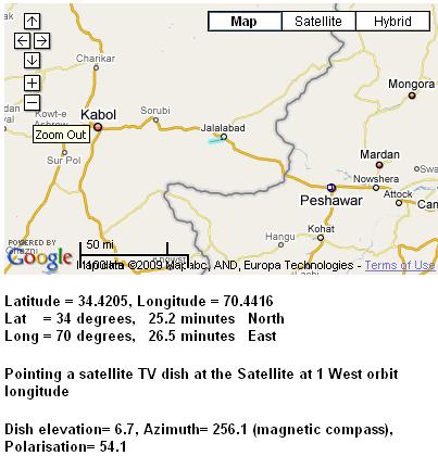
satellite dish pointing in Afghanistan it confirms that 6.7 deg is a plausible beam elevation angle for a site in Afghanistan aimed at INTELSAT 10-02 at 1 deg west longitude. I have picked Jalalabad as that gives 6.7 deg elevation. There are many other places in Afghanistan where the same angle applies along a line running roughly north-north-east to south-south-west.

The blue line shows the azimuth direction, which may help if you enlarge the image to see your location is more detail.
Regarding your dish, when the front face is upright the beam elevation angle is 22.6 deg.
You need a beam elevation angle of 6.7 deg so you need to tilt the top of the dish forwards by 15.9 deg.
I will guess that the vertical diameter of your dish is 190 cm.
If you dangle a weight on a 2.5m long string down from the top front of the dish the gap between the bottom of the dish and the string should be 190 x sin(15.9) = 52 cm
Your service provider should have told you the name of your receive polarisation.
If Receive = Horizontal then initially set the LNB arm upwards.
If Receive = Vertical then initially set the LNB arm sideways.
For Jalalabad the polarisation adjustment required is +54 deg. Use the correct angle for your location. Apply this positive adjustment amount by turning the feed assembly clockwise by 54 deg while facing towards the satellte in the sky. An inclinometer placed sideways across the LNB or BUC may help get this angle accurate.
Note that a beam elevation of 6.7 deg is rather low. The bottom back edge of the dish my tend to hit the pole or a diagonal brace. If so rotate the base ironwork. The low elevation beam means that mountains, trees, a wall or building may obstruct the beam. If you set up the elevation angle as above and then put your head behind the dish, just at the lower edge and look forwards just where is the feed assembly, then you should be able to see the sky. That is the approx direction of the lower edge of the beam. In hot humid weather you may notice the signal varying up and down in level due to scintillation, like the twinkling of a star near the horizon.
To find your satellite, set the beam elevation and polarisation as above. Set the modem tuning as told (use options file for iDirect). Then swing the dish boldly around the approx magnetic compass bearing (blue line). You should find the satellite on the first swing. If not try up and down 1 deg. If that fails try with the polarisation 90 different is case there is an error in the information. If no luck, check the LNB local oscillator frequency (e.g. 9.75, 10, 10.6, 11.3 GHz etc) the actual satellite downlink frequency (e.g. 11.123456 GHz) and the L band frequency in the options file (e.g. 1.123456 GHz)
.
Best regards, Eric.


