Advertisment: Broadband via satellite
Advertisment: Worldwide satellite services from Ground Control Company

www.satsig.net

Satellite Internet Forum.

Welcome, Guest.        Forum rules.
      Home            Login            Register          
Pages: 1

HX50 and AB1 coverage in Chile

(Read 5427 times)
Ysnw
Member
★★
Offline


Posts: 5
May 9th, 2011 at 5:43pm  
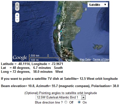
Trying to find out if anyone has successfully managed to lock in to Atlantic Bird 1 from any area close to southern chile.  Location is 48s and 73w using a 1.8 m dish.   Have been looking for a signal with little success:
Elevation: 10deg ( dish pointing down 12.5 for offset)
Azimuth: 55
Polarization: 38
Above are all approximate as I have scanned all around these parameters. 

Using Horizon meter have a max reading of 70 db and a max reading of 22 on hx50 signal strength meter at the direction of what I an sure is AB1.

Any suggestions would be greatly appreciated.  Thanks in advance

Back to top
 
 
IP Logged
 
USN - Retired
YaBB Moderator
★★★★★
Offline


Posts: 837
Kentucky (USA)
Reply #1 - May 10th, 2011 at 1:08am  
You should be in the ballpark, but it wouldn't hurt to double check the offset number for that dish. Given those general coordinates, I calculate Azimuth 54.7 magnetic, Elevation 10.7, Skew +38.1

I did notice magnetic deviation is 12.5 degrees in that region, so your compass might not be exactly trustworthy either.

//greg//
Back to top
 

USN (Ret)
 
IP Logged
 
Ysnw
Member
★★
Offline


Posts: 5
Reply #2 - May 10th, 2011 at 3:59am  
The dish is a TYPE 183 ANDREW with a 22.6deg offset angle.
I also had the advantage of a Furuno Sat Compass  on a boat about 100m from the Dish location so nailing down true and magnetic north was pretty simple. (Was even close to the compass on my Iphone which was surprising)

A pretty thorough scan has been done of all points from N to E at elevation angles -18 to 25 just to be thorough.   Spent 3 days looking for a lock so concerned that signal strength at this location may just be too weak.

Any additional comments or suggestions would be appreciated.
Back to top
 
 
IP Logged
 
USN - Retired
YaBB Moderator
★★★★★
Offline


Posts: 837
Kentucky (USA)
Reply #3 - May 10th, 2011 at 4:22am  
Well, the Lyngsat lists aren't always current. But from what I see it's important that you select a frequency that's actually on a South American beam; https://www.eutelsat.com/satellites/125e_popd.html

Also - unless/until you input the provider-specified satellite parameters via the HX50 user interface, it's not going to "see" a signal. Perhaps that's why you're seeing a 22. Is your HX50 signal supposed to be in South American coverage? Or are you trying to capture a Euro-frequency?

This coverage diagram may be of assistance to you as well: https://www.eutelsat.com/satellites/125e_popd.html

//greg//
Back to top
 

USN (Ret)
 
IP Logged
 
Ysnw
Member
★★
Offline


Posts: 5
Reply #4 - May 10th, 2011 at 5:11am  
Thanks for the prompt responses.
  The HX 50 config file is supposed to be set correctly according to the techs at B-W (it was preinstalled and I have confirmed settings).  The same goes for the Horizon meter although I cannot confirm settings as the Atlantic Bird South America just comes up as one of the factory satellites so do not know exactly what parameters are set in the meter.
Back to top
 
 
IP Logged
 
Ysnw
Member
★★
Offline


Posts: 5
Reply #5 - May 10th, 2011 at 5:18am  
A question on the coverage map.  Do you know what the white shading in the vicinity of my install location means.  I know I am working at the foot of the southern Patagonia icefields but really doubt the sat coverage maps are trying to show the glaciers. Smiley

Thanks,  Chris
Back to top
 
 
IP Logged
 
Admin1
YaBB Admin
★★★★★
Offline


Posts: 1189
Reply #6 - May 10th, 2011 at 9:44am  
...
...

Best regards, Eric
Back to top
« Last Edit: May 10th, 2011 at 1:54pm by Admin1 »  
WWW  
IP Logged
 
USN - Retired
YaBB Moderator
★★★★★
Offline


Posts: 837
Kentucky (USA)
Reply #7 - May 10th, 2011 at 11:45am  
Quote:
A question on the coverage map.  Do you know what the white shading in the vicinity of my install location means.  I know I am working at the foot of the southern Patagonia icefields but really doubt the sat coverage maps are trying to show the glaciers. Smiley
You'd have to contact EutelSat to confirm, but I suspect white indicates shadow. In other words - given the low elevation angle to AB1 from that area - it's my guess that the mountains block visibility between the white areas and the satellite

//greg//
Back to top
 

USN (Ret)
 
IP Logged
 
Admin1
YaBB Admin
★★★★★
Offline


Posts: 1189
Reply #8 - May 10th, 2011 at 4:51pm  
It makes sense to tilt the front face of the dish 12.5 deg forwards in order to get a beam elevation of 10 deg.
(22.5 - 12.5 = 10 )

If you have an inclinometer place it on a plank of wood and hold it at a 10 deg slope.  Get someone to look along the wood.  If they can see clear sky above the mountains then your dish can see the satellite.

At a beam elevation angle of 10 deg you may find that the bottom rear metalwork of the dish spine almost hits the pole.

If you get a signal level of 22 and the elevation angle seems right you have probably found the wanted satellite.  Peak up.

22 is a reasonable, but not brillant signal. The scale range is 0 to 29. The maximum for the signal power range is 29

The reason the 22 won't make the modem RX LED come on and the reading jump up to some signal quality reading like 80 with RX LED ON, is that one or more of the following are still wrong:

Polarisation initial setting and polarisation adjustment amount:  You need to start with the LNB pointing either directly upwards or sideways (the two different polarisation names). From either of these starting positions you need to turn the feed 37 deg clockwise as viewed from behind the dish and facing forwards towards the satellite in the sky (to the north east). You can quickly try both polarisation names by turning the feed 90 deg between the two alternative +37 adjusted positions.  One position will work perectly, the other not at all.  You may get good power readings at all angles.

Configuration settings:  Frequency, symbol rate, 22kHz tone ON/OFF and LNB menu type are important.  If there are errors then the modem receiver won't lock, even if peaked up on the wanted satellite (level=22).
Can you read out the information from the manual configuration screen?.  What is your LNB type and model number ?

Best regards, Eric.
Back to top
 
WWW  
IP Logged
 
Ysnw
Member
★★
Offline


Posts: 5
Reply #9 - May 10th, 2011 at 8:40pm  
You are correct about the mount almost coming in touch with the pole as I went as low as possible until it touched putting the angle at about 6 degrees off the horizon or -16 below vertical.

I tried all polarization setting as well in case my calculations where off but this only got me up to 22 on the HX50 siganl meter.  Off polarization readings are around 15.

Using a universal Hughes LNB HS 10.95-12.75Ghz.  P/N 1501882-0002.

I am back in the states now so unable to get the data from the modem but I do have the config file. 

I do have picture of the install but as well but I am still concerned that the signal may just be too weak at the location.  Have emailed Eutelsat  for clarification of their signal coverage map as well but no reply as of yet

Thanks again.

Chris
Back to top
 
 
IP Logged
 
Pages: 1