Advertisment: Broadband via satellite
Advertisment: Worldwide satellite services from Ground Control Company

www.satsig.net

Satellite Internet Forum.

Welcome, Guest.        Forum rules.
      Home            Login            Register          
Pages: 1

Help me please HX50 W3A Madagascar

(Read 9147 times)
dedeaux
Member
★★
Offline


Posts: 2
47.33E - Madagascar
Aug 24th, 2011 at 11:48pm  
Hey Everyone!

I have skimmed this forum and other pages in an effort to get my HX 50 setup going, but to no avail.

I have never setup a dish, not even for tv.

I would appreciate all the help possible.

I purchased a 1.8m dish and HX50 setup from WAFA.AE (linked on this site).  I have corresponded with their technicians, but have not succeeded in finding the W3A 7e sat from my location.

My specifics:  

Located in southeastern rain forest in Madagascar, gps:
21.17S, 47.33E.

As per the initial technician's response, I am to align the dish as follows:
Dish elevation (deg): 39.96°
Dish azimuth (deg east relative to true north): 291.07°
Dish azimuth (deg east relative to magnetic north): 305.82°
Polarisation angle (deg): 62.07°
Clockwise rotation whilst standing in front of the feed assembly, facing the dish

I have attempted to set the elevation at said degrees, measuring the angle with my phone's inclinometer app -- placing the phone against the bar on the back of the dish.

I purchased a meter -- Maxpeak Sam-lite DVB-S, and flashed it with what I believe are the correct settings.  The meter reads that it is searching for HX W3A 7E.

So, here is my issue -- I can't find the satellite.  I have spent literally days panning back and forth to no end.  The meter usually reads 63-64db and says searching always.  However, I have lowered the elevation to nearly vertical (the dish) and panned further west (i.e. maybe 260 degrees instead of the suggested 290) and see the signal jump to 69.  Does this mean I am on the right track?  

The problem is that at that level there are a handful of trees which the dish is pointing at, and will likely need to be trimmed.  Problem I have is my landlord isn't too hip on that, so I need to be absolutely sure before I trim them.

Thanks for reading and helping.

Jeremy Newton

I don't have internet at home, hence the setup.  So, posting my responses might be delayed.
Back to top
« Last Edit: Aug 29th, 2011 at 9:50am by Admin1 »  
 
IP Logged
 
Oasis Networks
Senior Member
★★★
Offline


Posts: 232
Reply #1 - Aug 25th, 2011 at 7:26am  
Hello!

First of all, dont give up yet. pointing a dish, especially in Ku band, without proper equipment for the first time is not easy. If you or the service provider can not efford sending someone to the site and help you, please consider the following notes.

1. About elevation - The elevation you mentioned is the true elevation. But most probably your dish has an offset, probably around 22 degrees. Plus, you placed the inclinometer at the right place, but as the bar behind the dish is perpendicular to the looking angle, so calculating with the offset as well, you need to look for readings in your inclinometer of around 72 degrees. This should be your starting point. You can see that when you elevate the dish to this reading, the dish is mechanically elevated around 20 degrees ( 18 ) above the horizon.
2. Once you are there, you need to do the following:
- Either you connect your satmeter, and make sure and double sure and triple sure you have put the right parameters in it.
- Or you connect your modem - and again, you make sure that the settings are all good there.
3. Take a deep breath, be patiant and do the following:
- point the dish more or less to the azimuth, and chech your meter. Then, start move it left and right, VERY slowly (it is Ku band), and every now and then make sure the elevation is still the same. If your mast is not 100% vertical, when you will move the dish on azimuth the elevation will be changed.
Anyway, sweep very gently and see if you can get anything.
Then, change elevation 1 deg (either up or down), and again sweep azimuth axis. Repeat this action slowly, with calm, and eventually you will probably get the bird. Also, make sure you are on the right polarity. It wouldnt be a bad idea to try the other polartity as well, from my experience, many times NOC guys are sitting very comfortably in their airconditioned room and they have no idea what is the polarity needed.

Another point worth checking is to make sure you are under the coverage of the satellite. In SE Madagascar W3A is not so powerful as in Antanarivo for example. Make sure with the NOC that you are supposed to be in a coverage area with your dish.

Another point is to make sure that your line of sight it clear. For your looking angle, more or less if you have a tree 10m high and 10m away from the dish, for example, it will block you. Make sure your line of sight is clear.

If all this fail - we will be able to assist you, we can dispatch and engineer from Antanarivo.

Good luck,
Nimrod
Back to top
« Last Edit: Aug 29th, 2011 at 9:49am by Admin1 »  

www.oasisnetworks.net - Oasis Networks - Online with you!
IP Logged
 
dedeaux
Member
★★
Offline


Posts: 2
47.33E - Madagascar
Reply #2 - Aug 25th, 2011 at 12:39pm  
Thanks for the tips.  We are actually in Antanarivo until tomorrow and I had thought about looking to hire a technician to come an help get the dish running.  I have scheduled with my landlord to come and trim the tree(s), but she isn't very happy at all.  I wanted to be sure I needed to cut them before proceeding.  In the area around my house, I can't see a place that would offer better line of sight, but a technician would be more knowledgeable.

Wafa never mentioned installation, and I assumed it was all self-install anyway.  However, I am not against hiring a technician/engineer within the country as long as they can get it set up.

Also, I dialogued extensively about my location and Wafa assured me the solution would work, and this is also why I went with the 1.8m dish as opposed to 1.2m.

You are free to pass my contact information along to someone here in country.  I can PM my phone number if needed.

Jeremy
Back to top
« Last Edit: Aug 29th, 2011 at 9:49am by Admin1 »  
 
IP Logged
 
Gary-BW
Member
★★
Offline


Posts: 12
Reply #3 - Aug 27th, 2011 at 9:51am  
Good Morning Sir,
I have contacted WAFA on your behalf and discussed your case with them. I have reviewed the photographs and can see that one of our RF engineers mentioned the below:

"You need to move the marker on the TX BUC to +56 on the degree scale at the front of the BUC.
Also looking at the skew on the antenna I think your antenna should be a lot higher, it is 38 degrees of elevation to the satellite. What I suggest is you start the antenna higher than 38 degrees and work the antenna down a degree at a time panning 30 degrees east and then west of 293 degrees azimuth."

Did you implement the above recommendations? Also; please confirm the P/N number of the receive LNB.
Back to top
 

Tel: +44 (0) 23 9231 1118  Web: www.bentley-walker.com Email: gary@bentleywalker.com  MSN: gary_del@hotmail.com
WWW | YIM  
IP Logged
 
Admin1
YaBB Admin
★★★★★
Offline


Posts: 1205
Reply #4 - Aug 29th, 2011 at 9:45am  
Quote:
I have attempted to set the elevation at said degrees, measuring the angle with my phone's inclinometer app -- placing the phone against the bar on the back of the dish.

If you have a 1.8m offset fed dish (strong feed support arm at the bottom) and set the front face of the dish vertical then the beam elevation is the same as the dish offset angle.  I don't know your dish offset angle but it might be some number like 17.3 deg - read your documentation. If you need a beam elevation of 39.96 deg then start with the front face of the dish vertical (dangle a plumb bob string down the front) and apply your inclinometer to the back. Your inclinometer will read zero or 90, or 180 or 270, depending on which way round you hold it.  Now tip the top of the dish backwards by an amount of 39.96-17.3 = 22.66 deg.  Your inclinometer will read 22.66 different from before.

What name polarisation have you been told to receive?.
What is the model number of your LNB ?
Please confirm your GPS lat/long coordinates. e.g. Do you mean 21.17 deg South, or 21 deg 17 minutes South ?

Best regards, Eric.
Back to top
« Last Edit: Aug 29th, 2011 at 10:53am by Admin1 »  
WWW  
IP Logged
 
Eric Johnston
Senior Member
★★★
Offline


Posts: 2109
Reply #5 - Sep 2nd, 2011 at 9:46am  
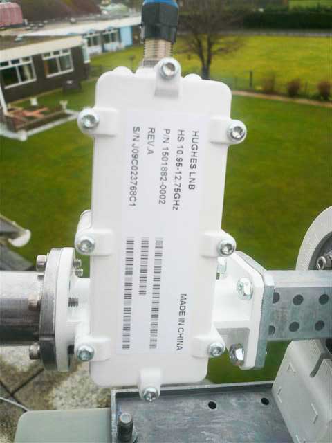
This image, from a CD supplied by WAFA, shows a Hughes Universal OMT/LNB Part number 1501882-0002 10.95-12.75 GHz.

...

The image shows an incorrect position for the single tick mark on the adapter tube. The single tick mark must be always be directly away from the feed support arm.

As shown, the LNB is oriented so that receive polarisation is exactly vertical and transmit polarisation is exactly horizontal.   This is the starting position if the wanted receive polarisation is Vertical name.

I am assuming a 1.8m dish with the feed support arm fixed at the bottom.

I've just spoken with Bentley Walker and they say that you should be receiving Horizontal name polarisation (W3A 7E Southern Africa, HX service).  This means that you must turn the whole Feed/LNB/BUC assembly, as shown in the picture, 90 deg so that the LNB connector points out horiziontally at the side. The labels on the LNB will be upwards. The single tick mark will be upwards - good ! This is now the correct starting position for Horizontal receive polarisation.  

For Madagascar and W3A satellite at 7 E a polarisation adjustment now needs to be applied.  This is -59 deg anti-clockwise as viewed facing forwards towards the satellite in the sky.  The satellite is towards the north west.

Turn the LNB and BUC (but not the feed horn or spacer tube) -59 deg anticlockwise, as viewed facing towards the satellite in the sky.  Undo the 6 screws and reattach the circular flange so that the single tick mark remains near the top,  as best you can. The 12 holes will mean you can get it within +/- 15 deg. That will have to do.

====

Using
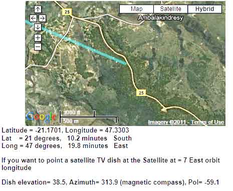
https://www.satsig.net/maps/satellite-tv-dish-pointing-south-africa.htm
This shows the dish pointing for Madagascar and W3A at 7 east.
...

Best regards, Eric.

Back to top
 
 
IP Logged
 
Eric Johnston
Senior Member
★★★
Offline


Posts: 2109
Reply #6 - Sep 6th, 2011 at 6:28pm  
I don't know what time zone you are in.  What time is your local sunset on 7th Sept?.

If the sun sets at 18:40 then at time 16:10 the sun is on true bearing of 293.4 and elevation 33.7

If you can see the sun at that time then your dish can see the satellite in the same direction at an elevation of 38.5 deg.

If your time of sunset is 17:40 or 19:40 etc.,  then just adjust whole hours either way.

Best regards, Eric
Back to top
 
 
IP Logged
 
Admin1
YaBB Admin
★★★★★
Offline


Posts: 1205
Reply #7 - Sep 10th, 2011 at 5:28pm  
Beam elevation
WAFA have told me that your dish is Prodelin Type 1183/1184
Assembly manuals for all Prodelin antennas are listed here https://www.gdsatcom.com/vsat_assembly.php
Both these designs have a beam elevation offset angle of 22.3 deg
If you set the front face of the dish vertical the beam elevation is 22.3 deg.

In order to get the beam elevation up to 38.5 deg you need to tip the top of the dish backwards by an amount of 38.5 - 22.3 = 16.2 deg.

Check the initial verticality of the front of the dish using a plumb bob.
Put an inclinometer at the back and tilt backwards by an amount of 16.2 deg.
Make an inclinometer if necessary: https://www.satsig.net/pointing/how-to-make-inclinometer.htm

Polarisation
You are supposed to be receiving Horizontal name polarisation.  Start with the Hughes Universal LNB F connector sticking out directly sideways, on the right hand side, as viewed with you standing behind the dish and facing forwards towards the satellite in the sky (to the north west).
Stage 2 of the polarisation setting is to apply the adjustment of minus -59 deg. Lift the LNB upwards, anticlockwise by an amount of -59 deg.  Use the scale tick marks to measure the amount. If the numbers go backwards from 90 ignore the numbers; it is the amount and direction of adjustment that matters.

HX50 modem configuration
Have you input the carrier frequency and symbol rate etc from your configuration sheet ?  Once you have done this, simply swing the dish boldly sideways to find the satellite. If nothing found, go up 0.5 deg and swing again. The various satellites are in a sloping diagonal line across the sky, down in the north west and high up at due north.

Today (10 Sept 2011) and for the next 9 days the sun's path across the sky passes through the positions of satellites. Is your dish illuminated by the sun in the afternoon and until what time ?  What time is sunset ?

You may get signal power readings of up to 29 initially (on any satellite), and then up to 100 once your modem locks to the wanted carrier, i.e. on the correct satellite, correct polarisation and with correct tuning config in the HX modem.
wxw
Best regards, Eric.
Back to top
« Last Edit: Sep 15th, 2011 at 10:52am by Admin1 »  
WWW  
IP Logged
 
Pages: 1