Locating the lost MH370 aircraft
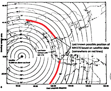
The map below has been released to help find the lost MH370.

This illustrates how a site may be located, somewhere on a circle of specific radius, centered on the sub-satellite point which is on the equator. The teleport tells the site to transmit a burst and the teleport then receives the response and measures its time of arrival. Thus the teleport knows the range from the site to the satellite.
The circles around the sub-satellite point relate to different ranges to the satellite, and corresponding elevation angles.
If you can repeat the location process with a different satellite you get two intersecting circles and thus two quite specific possible locations, where the rings cross. In the case of omnidirectional antennas (portable or mobile sites), reception on multiple satellites is easy.
Most VSATs operate TDMA on their uplink and the exact timing of all transmit bursts is closely controlled, and adjusted as necessary, so that bursts from other sites on the same network do not overlap when they arrive at the satellite. At site commissioning it is normal for the lat/long of the site to be used so that the initial burst can be predicted to arrive in an empty 'acquisition window' time slot in the TDMA frame. Once acquired, the burst timing may be adjusted to get the burst to the middle of its assigned time slot. See my
explanation of TDMA.For the purpose of locating VSATs, there is the problem that a VSATs has directional dish antenna, so that only one satellite will get a strong signal. Other satellites will get much weaker signals. The weak signals are difficult to detect but once the wanted signal is known it may be used to correlate with the weak signal and drag it up out of the noise floor.
Best regards, Eric
I've found some more discussion of this topic here:
https://tmfassociates.com/blog/2014/03/15/understanding-satellite-pings Signal amplitude measurements may help as well, particularly if the satellite has multiple spot beams.
The map shown above relates to reception on an older INMARSAT 3 satellite at 64 east orbit position, with a global beam, where burst timing helps define a circle of possible locations.
Inmarsat 4 satellites have spot beams. One is INMARSAT 4A EMEA located at 24 deg east orbit position. The other is and INMARSAT 4 located at 143.5E (ASIA-PACIFIC). Looking either way there is spot beams coverage from both satellites between 70E and 102 deg east (on the equator). Using spot beams it may be possible to narrow down the search.


