Advertisment: Broadband via satellite
Advertisment: Worldwide satellite services from Ground Control Company

www.satsig.net

Satellite Internet Forum.

Welcome, Guest.        Forum rules.
      Home            Login            Register          
Pages: 1

how to use inclinometer?

(Read 7132 times)
Tr0y
Member
★★
Offline


Posts: 3
Sep 15th, 2014 at 11:10am  
Hi,
first of all i'm sorry if this is the wrong section
really i want to thank you for this wonderful site
i got so many useful information about sats and dishes
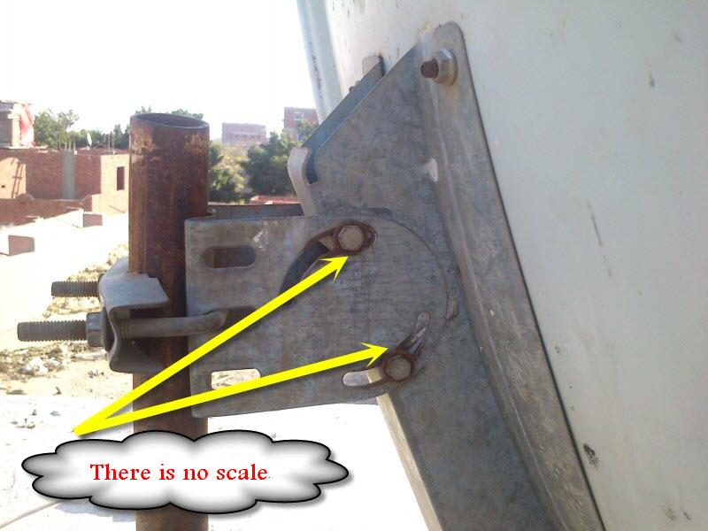
i have an old offset dish that don't contain elevation scale
it has nearly 23 deg. offset angle
so i want to know where to put your homemade inclinometer to measure the elevation angle
here are some pics to the dish for illustration
please tell me where should i put the inclinometer
sorry for bad english and advanced thanks
Back to top
 

3cuJkZ.jpg (53 KB | 366 )
3cuJkZ.jpg
 
IP Logged
 
Admin1
YaBB Admin
★★★★★
Offline


Posts: 1203
Reply #1 - Sep 15th, 2014 at 1:55pm  
Set the front of the dish vertical.  The beam elevation will be 23 degrees.

Put the inclinometer against some convenient surface, e.g the front side, the rear flat plate.  Read the angle on the inclinometer.

If you want a beam elevation of 30 deg, tilt the dish backwards by an amount of 7 deg. Use the inclinometer scale to count off a movement of 7 deg.

If you want a beam elevation angle of 20 deg, tilt the top of the dish forwards by an amount of 3 deg.  Use the inclinometer scale to count along by 3 deg.

Best regards, Eric.


Back to top
 
WWW  
IP Logged
 
Tr0y
Member
★★
Offline


Posts: 3
Reply #2 - Sep 16th, 2014 at 8:02am  
Quote:
Set the front of the dish vertical.  The beam elevation will be 23 degrees.

Put the inclinometer against some convenient surface, e.g the front side, the rear flat plate.  Read the angle on the inclinometer.

If you want a beam elevation of 30 deg, tilt the dish backwards by an amount of 7 deg. Use the inclinometer scale to count off a movement of 7 deg.

If you want a beam elevation angle of 20 deg, tilt the top of the dish forwards by an amount of 3 deg.  Use the inclinometer scale to count along by 3 deg.

Best regards, Eric.


Thank you man for quick response
but where is the best place to get accurate reading
the yellow arrow or the blue arrow?
and sorry for inconvenience
Back to top
 

18gds.JPG (40 KB | 372 )
18gds.JPG
 
IP Logged
 
Admin1
YaBB Admin
★★★★★
Offline


Posts: 1203
Reply #3 - Sep 16th, 2014 at 12:54pm  
l would use the metal at the back, the blue arrow, as at this place the inclinometer will be visible to you when you adjust the elevation.

Also, there is a chance that this surface may be at right angles to the beam direction.

Once you have set the elevation, loosen the pole clamp only enough to allow you to swing the dish boldly sideways to find a satellite. You will need to hold the dish to prevent sagging or sliding down the pole while the clamp is loose. Once you have found any satellite mark the metal so you can quickly get back to this start position. Then move in steps to the wanted satellite.

Best regards, Eric.
Back to top
 
WWW  
IP Logged
 
Tr0y
Member
★★
Offline


Posts: 3
Reply #4 - Sep 17th, 2014 at 10:32am  
Thank you man
you are the best
Best regards
Back to top
 
 
IP Logged
 
Pages: 1