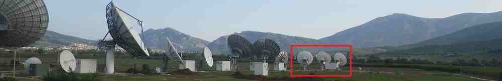
O3b satellite orbit and beams.
Reload the page to restart the animation.
The green figures are the start up default values. This page displays an educational animation of some known and some possible spot beam pointing directions from a constellation of O3b satellites orbiting around above the equator at a height of 8064 km. The satellites are progressively moving forwards, eastwards and as one sets in the east, another has just risen in the west. Provided you have two motor driven tracking antennas you can maintain 24 hr service. Note where the big circles intersect and overlap. These overlap areas are where you will have dual illumination for a period of time allowing you to switch antennas without interruption.
| This page is purely for educational purposes. Most example beam centres (or earth station locations) shown are hypothetical and not actual. Some sites are shown because they have been mentioned on the internet as possible locations. These include Perth, Dubbo in Australia, Hargeisa in Somaliland, Sintra in Portugal, Palau, Hawaii, Port Moresby in Papua New Guinea, Cook Island and Pitcairn in the Pacific, Juba Sudan, Malaysia x2, Madagascar, Kinshasa in DR Congo and Lurin, Peru. |
In the case of Cook Island several sites are included in a single beam coverage: Raratonga, Aitutaki, Aitu, Mangaia and Mauke. You need to drag the map and enlarge the scale, so you can see the South Pacific and Cook ilands in detail for this. Activate the beam pattern drawing option by typing Lat=-20.34 and Long=-158.75 then click "Add Site". You will see how a beam pointed a place over the sea in the vicinity of the Cook Islands manages to provide coverage for five Pacific islands simultaneously with service by Cook Islands Telecom.
16 Nov 2014: There are now 8 satellites in orbit. They are located at 6 orbital positions, at 60 deg increments, around the orbit. Two pairs of satellites are approximately co-located: FM4 with FM5 and FM2 with PFM.
10 Jan 2014: Added illustrative beam for Kabul, Afghanistan.
16 Jan 2014: Added Hortolandia in Brazil.
20 Jan 2014: Position of beam for Papua New Guinea was amended today to aim towards Port Moresby.
19 June 2015: Added 1400km orbit height to allow simulation of Leosat, a proposed system of 80-120 polar orbiting satellites, each with 12 steerable spot beams and 10 Gbit/s per satellite. Also noted recent announcement of O3b beam to be aimed at East Timor (TimorLeste), already included in model.
7 April 2016: Location of the gateway Greek hub is believed to be at the Nemea teleport.
It is possible to plot the beam coverage for one beam only. This illustrative site must be created using the lat/long selection at the top right. Point it anywhere you want. Note that maths 'blows up' for extreme north or south latitudes where the elevation angle goes negative, but at least it give you some idea. I have been unable to find this bug in the program.
Each satellite has 12 steerable spot beams. I believe that two of these will be aimed at gateway earth stations where high speed connection to the terrestrial internet network will be possible. That leaves 10 customer beams per satellite. My program does not at present limit the number of beams, so if you see in excess of 12 beams per satellite that is a further bug in my program.
The number of satellites shown is 4, corresponding to the first launch and the even spacing at 90 deg longitude corresponds to the orbit spacing in mid Nov 2013. With further launches planned, the spacing may be decreased and further to the north and south it will become possible to obtain 24 hr service. A factor affecting this is the minimum elevation angle used by customers. If you are prepared to accept low elevation operation (5 - 10 deg) then the potential for near 24hr service extends further north and south, but with increasing problems of rain attenuation and scintillation.
The animation allows the minimum elevation angle to be changed. These are geometric angles and are not adjusted for atmospheric refraction. The 0 deg elevation angle is relevant to possible operation with high flying aircraft.
For the O3b satellites, the increment in the animation is 2 deg along the equator, so there are 180 steps for a satellite to go all the way round. The orbit period is 288 minutes and the earth surface moves forwards by 72 deg (15 deg per hour) during this time, so the actual ground progress during one orbit is only 288 deg. A full orbit takes 360 minutes, so 1 minute per degree or 2 min per 2 deg increment in the demo above. The software increments occur every 2 sec, to allow time for slow software to redraw all the lines etc before the next step starts. So it is speeded up by a factor of 2 min / 2 sec = 60 times.
Note the possibility for part time operation in the north or south areas, where there is not 24hr coverage.
As of 15th Nov 2014 the 2-line orbital elements were:
O3B FM5
1 39188U 13031A 14318.21238429 -.00000028 00000-0 00000+0 0 1302
2 39188 0.0402 340.8502 0003409 258.5822 120.5402 5.00116345 25340
O3B FM4
1 39189U 13031B 14319.80999792 -.00000024 00000-0 00000+0 0 1199
2 39189 0.0365 12.6065 0004704 164.5854 182.8169 5.00116116 25423
O3B FM2
1 39190U 13031C 14318.71113596 -.00000027 00000-0 00000+0 0 1351
2 39190 0.0337 18.5552 0005494 151.5253 189.9362 5.00116818 25361
O3B PFM
1 39191U 13031D 14318.91227733 -.00000026 00000-0 00000+0 0 1251
2 39191 0.0363 345.0100 0003534 248.9282 126.0345 5.00117152 25381
O3B FM3
1 40079U 14038A 14317.87935241 -.00000028 00000-0 10000-3 0 470
2 40079 0.0345 355.6113 0003596 274.2875 90.0652 5.00115714 6312
O3B FM7
1 40080U 14038B 14318.37904545 -.00000027 00000-0 00000+0 0 352
2 40080 0.0358 359.0183 0002588 250.3396 110.6198 5.00116435 6366
O3B FM6
1 40081U 14038C 14318.34578212 -.00000027 00000-0 00000+0 0 392
2 40081 0.0346 354.3445 0002521 243.6610 121.9770 5.00116148 6366
O3B FM8
1 40082U 14038D 14318.44562285 -.00000027 00000-0 00000+0 0 443
2 40082 0.0362 0.8352 0003778 230.7061 128.4307 5.00116250 6347
As of 20 Nov 2013 the orbital 2 line elements were:
O3B FM5
1 39188U 13031A 13323.80928555 -.00000028 00000-0
00000+0 0 464
2 39188 0.0369 359.8467 0001684 239.3466 120.7949
5.00114703 7362
O3B FM4
1 39189U 13031B 13322.55940486 -.00000028 00000-0
10000-3 0 390
2 39189 0.0361 358.2964 0001026 0.7257
0.9823 5.00115079 7309
O3B FM2
1 39190U 13031C 13323.85943929 -.00000028 00000-0
10000-3 0 357
2 39190 0.0424 0.2873 0002075 245.0451 114.6504
5.00113715 7369
O3B PFM
1 39191U 13031D 13319.91170817 -.00000028 00000-0
00000+0 0 410
2 39191 0.0405 359.7692 0001838 243.6079 116.6089
5.00115309 7165
The key figures in these 2-line data sets are explained below:
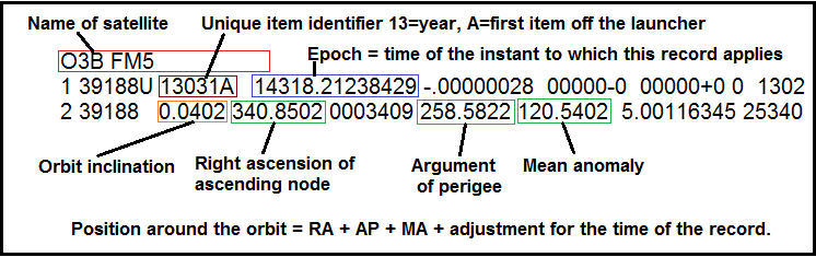
The position of each satellite along the orbit, directly above the equator, is calculated using the time to which the the record applies plus the addition of the Right ascension of the ascending node, the Argument of perigee and the mean anomaly. Note the inclination is near zero, meaning the satellite is going along above the equator.
Palau added 17 Feb 2015
Meosat facility added in Basrah, 18 August 2015
2 line elements 16 July 2016 below:
O3B FM5
1 39188U 13031A   16197.68817099 -.00000023  00000-0  00000-0 0  9995
2 39188   0.0416 339.4294 0003288 321.2311  59.3062  5.00115633 55841
O3B FM4
1 39189U 13031B   16197.18032388 -.00000024  00000-0  00000-0 0  9992
2 39189   0.0342  21.2327 0006986 106.0690 232.7611  5.00115732 55847
O3B FM2
1 39190U 13031C   16197.15527651 -.00000024  00000-0  00000-0 0  9993
2 39190   0.0312  28.3905 0007595  99.3842 232.2933  5.00115713 55814
O3B PFM
1 39191U 13031D   16197.17875005 -.00000024  00000-0  00000-0 0  9995
2 39191   0.0372 349.7829 0002441 141.9789 228.2581  5.00115166 55811
O3B FM3
1 40079U 14038A   16197.49001594 -.00000023  00000-0  00000-0 0  9998
2 40079   0.0332   6.1004 0000500  53.5329 300.3708  5.00115278 31939
O3B FM7
1 40080U 14038B   16197.24563381 -.00000023  00000-0  00000-0 0  9990
2 40080   0.0342   9.5712 0002005  97.6460 252.8038  5.00117031 36708
O3B FM6
1 40081U 14038C   16197.46742576 -.00000023  00000-0  00000-0 0  9990
2 40081   0.0337   7.6699 0001571  95.6504 256.6963  5.00115573 36696
O3B FM8
1 40082U 14038D   16197.11246696 -.00000024  00000-0  00000-0 0  9996
2 40082   0.0343  13.0114 0002560 127.4322 219.5742  5.00115348 36781
O3B FM10
1 40348U 14083A   16197.33480990 -.00000023  00000-0  00000-0 0  9991
2 40348   0.0345 355.6362 0003122  98.0393 266.3593  5.00114998 28756
O3B FM11
1 40349U 14083B   16197.75641250 -.00000023  00000-0  00000-0 0  9996
2 40349   0.0364 353.3953 0003169 111.0644 255.5747  5.00116041 28779
O3B FM12
1 40350U 14083C   16198.42288629 -.00000022  00000-0  00000+0 0  9998
2 40350   0.0363 355.2224 0002805 119.0235 245.7827  5.00115773 28818
O3B FM9
1 40351U 14083D   16197.00142331 -.00000024  00000-0  00000-0 0  9994
2 40351   0.0356 352.0644 0002922 107.9342 260.0334  5.00115408 28769
16 July 2016: There are 9 orbit positions occupied, at 40 deg orbit spacing intervals around the equator. The satellites are in the sequence:
FM2/PFM (2.8 deg apart)
FM10
FM12
FM7
FM6
FM5/FM3 (1 deg apart)
FM8
FM10
FM2/FM11 (2 deg apart)
The ones that are approximately co-located are probably acting as spares for one another.
|
Comments and feedback please to eric@satsig.net Also, say if you have suggested text to add to this page. Page created 20 Nov 2013, last amended 27 Feb 2018, 2 March 2022, 26 Jul 2025, 27 Feb 2026, 27 March 2026. |