|
|
Find your latitude and longitude |
Explanation of Azimuth and Elevation
Azimuth and elevation refer to the satellite TV dish pointing angles.
Elevation
Elevation refers to the angle between the beam pointing direction, directly towards the satellite, and the local horizontal plane. It is the up-down angle.
When your dish is pointed low down near the horizon the elevation angle is only a few degrees. At low elevation angles, below 5 deg at C band and 10 deg at Ku band, the path through the atmosphere is longer and the signals are degraded by rain attenuation and rain thermal noise. Scintillation also occurs, particularly in hot humid weather. This causes increases and decreases in the signal level every several seconds for many hours, like the twinkling of a star.
When your dish is pointed almost straight up the elevation angle is nearly 90 degrees. Sites near the equator may require you to point to almost 90 deg elevation angle when the longitude of the satellite is similar to the longitude of the site location. In high elevation cases watch out for the possibility of rain water collecting in the dish.
It is easy to set up the elevation angle accurately, using:
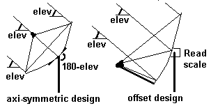
(a) a scale marked on the mount bracket. This is almost essential for 'offset antennas' where the feed/LNB is supported by a feed support arm at the bottom. Make sure the pole mount is vertical using a bubble level or weighted string in two positions at right angles around the pole. The offset angle may be documented in the installation instructions. If you have an offset dish and have the front face of the dish vertical, then the beam elevation angle is the same as the documented offset angle.
(b) using an inclinometer. These typically have a bubble level and a rotary scale marked in degrees. Think about low angles (near zero), the 45 deg half way angle and high angles (towards 90 deg) and make sure that your scale readings make sense. You may need to add or subtract 90 or 180 deg and even to read the scale backwards. If you are using an axi-symmetric dish the back of the dish is normally at right angles to the beam and there may be some suitable flat part where you can apply the inclinometer.
(c) If you don't have an inclinometer then make an inclinometer using a piece of card, a length of cotton and a small weight (small metal nut, for example). Make a hole near one edge and insert the thread so that the weight dangles across the card. Draw on the card the exact elevation angle required using a school compass or two lines at right angles and trigonometry (tan function suggested) at Start, Programmes, Accessories, Calculator, Scientific mode. This kind of home made device can be far more accurate that a small inclinometer sold in a DIY store. For large dishes a long plumb line can be used and sideways measurements used with tan tables to determine angles accurately.
Azimuth
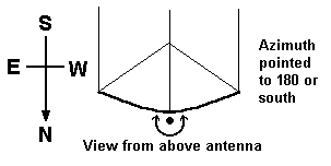
Azimuth refers to the rotation of the whole antenna around a vertical axis. It is the side to side angle. Typically you loosen the main mount bracket and swing the whole dish all the way around in a 360 deg circle.
By definition North is 0 deg, East is 90 deg, South is 180 deg and West is 270 deg. North can also be called 360 deg.
Note that you find a satellite by pre-setting the elevation accurately and then swinging the whole antenna boldly in azimuth till the signal locks up - so an approximate azimuth angle is normally sufficient.
The dish pointing calculator gives the required azimuth angle both relative to true north and relative to magnetic compass north.
When using a magnetic compass keep away from metal structures. This is obviously a problem in many cases both with the antenna steelwork and building structures. If, for example, you have a close angle clearance problem with say an adjacent wall then you may need to walk some distance away and sight towards the satellite from say 50 yards back. Large scale precision maps / plans can be useful in accurately defining angles. Also consider long range views of say church towers that might provide an accurate azimuth reference.
If you are in the northern hemisphere then remember that the sun rises in the east, reaches its highest angle at due south and sets in the west.
If you are in the southern hemisphere then remember that the sun rises in the east, reaches its highest angle at due north and sets in the west.
If you are away from the equator and it is a sunny day you can approximately determine south simply by considering where the sun is and the general time of day. To calculate sun or moon angles at any time go here:
https://aa.usno.navy.mil/data/AltAz
or sun only go here:
https://gml.noaa.gov/grad/solcalc/azel.html
Sun or moon altitude is the same thing as elevation angle.
If you are near the equator note where the sun rose this morning - that is approximately east.
The north pole star gives a good fix if you are in the northern hemisphere and not too close to the equator. Here is how to find true north using the pole star.
Some GPS receivers show a view of the sky with the sun and moon marked. Line up with one of these and you have a good bearings. Also with GPS you can walk a while in a straight line and determine the azimuth bearing angle of that line.
Dish pointing angles for all geostatioary satellites
If you want the azimuth and elevation angles for all visible geo satellites
from your location go here:
https://www.satsig.net/pointing/dish-pointing-angles-for-all-geo-satellites.htm
|
Page 24 Oct 2004, amended 24 July 2025. Any problems, please email me, eric@satsig.net |