Advertisment: Broadband via satellite
Advertisment: Worldwide satellite services from Ground Control Company

www.satsig.net

Satellite Internet Forum.

Welcome, Guest.        Forum rules.
      Home            Login            Register          
Pages: 1

Finding your latitude and longitude

(Read 128389 times)
Eric Johnston
Senior Member
★★★
Offline


Posts: 2109
Dec 7th, 2005 at 11:37pm  
ref: https://www.satsig.net/maps/lat-long-finder.htm

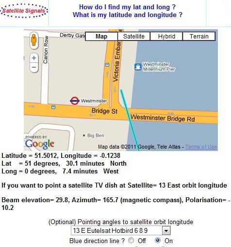
Click on "Satellite" at the top of the map and it changes the display so you can see the ground. Zoom in and try to work out from the main roads, where is your location. The resolution varies from place to place but roads are normally quite clear.

There is a problem for people located out in the country away from features which they can recognise. They may find it difficult to even find their town or village in the first place without more guide markers for the more significant towns.

I have just added Al Madinah, and marked a cross roads where you can see the traffic waiting.

Best regards, Eric.
wxw
Back to top
« Last Edit: Jan 31st, 2020 at 1:19pm by Admin1 »  
 
IP Logged
 
Ex Member
Ex Member


Reply #1 - Dec 8th, 2005 at 12:55pm  
Eric
This site is even better than i thought . roads are clear you can actually use main roads and highways to get  latitude and longitude of any location within Riyadh
Thanks for this great site
Back to top
 
 
IP Logged
 
Ex Member
Ex Member


Reply #2 - Dec 21st, 2005 at 2:04pm  
it is great tool thank you very much .it help me so much in adjesment my dish in iraq-basrah. thank again
Back to top
 
 
IP Logged
 
Ex Member
Ex Member


Reply #3 - Jan 1st, 2006 at 4:19pm  
hi eric,

I'm a new user here.I hav something to ask .my latitude 5.98 & longitude
116.07. 
I intend to set up my new satelite dish system
6feet dish with actuator and a C-band LNB(dual polarity voltage switching).
Do i need to buy another KU-band LNB?
thanks alot!
Back to top
 
 
IP Logged
 
Eric Johnston
Senior Member
★★★
Offline


Posts: 2109
Reply #4 - Jan 1st, 2006 at 5:33pm  
I've just had a look to see where you are using page https://www.satsig.net/maps/satellite-photo-image-viewer.htm It is nice to hear from someone so far away and still be able to see where they live. Happy New Year to you.

There are a mixture of C band downlinks and Ku band downlink beams in your area and you need to do a lot of studying on https://www.lyngsat.com to determine which TV programmes can be received in your area. You need to access the beam maps by clicking the links in the column "beam".

I suggest you get your C band system working first and find out what you can see.

Regarding adding a Ku band feed and LNB. If the dish is a mesh dish intended for C band operation it may give a poor performace at Ku band. You need a surface profile accuracy of about 3mm or better for Ku band.
If the dish is solid you may be OK but check the rim is flat using crossed fishing lines.

Ideally you need a combined C and Ku band feed with a single horn.

If not, you may be able to put a Ku band feed alongside the C band feed and get a degraded performance perhaps similar to a 4-5ft Ku band dish. The extra feed needs to be to the side of the C band feed and you will need to be aware of the difference in polar mount pointing angle for C and Ku bands, for the same satellite. It sounds difficult.

I repeat my advice - get the C band system working well first and see if the programmes are what you want.

Best regards, Eric.
Back to top
« Last Edit: Jan 31st, 2020 at 1:20pm by Admin1 »  
 
IP Logged
 
Ex Member
Ex Member


Reply #5 - Jan 2nd, 2006 at 4:08pm  
hi eric,

thanks again.
Back to top
 
 
IP Logged
 
toxic
Guest


Reply #6 - Jan 6th, 2006 at 1:54pm  
Mr Johnson

I.ve been trying to use the map to find echostar 110 and 119 in medicine hat alberta on a 20 inch skewable dish but not having any luck getting the dish set up, i think i am scewing up entering the latitude and lonitude somehow, wouldn't mind some help

thanks
toxic
Back to top
 
 
IP Logged
 
Eric Johnston
Senior Member
★★★
Offline


Posts: 2109
Reply #7 - Jan 6th, 2006 at 4:57pm  
Using https://www.satsig.net/maps/lat-long-finder.htm

I've just been able to find Medicine Hat, Alberta, Canada, in the map view with no problem. The resolution of the satellite images is not anything to rave about but the individual streets are named OK on the maps.

You latitude is approx 50 deg 3 min north and longitude 110 deg 41 min west. Please write this down for reference.
wxw
If you can't make the map work please explain more. I need to know in order to make improvements. Some types of browser may not work, for example.

Try my new satellite finder at https://www.satsig.net/sf.htm

You can input your location, latitude and longitude in degrees and minutes using the mouse. Also select your wanted satellites, one at a time, and write down the dish azimuth (magnetic), elevation and polarisation angles for each satellite you want.

I am assuming that your dish is intended to be fixed and has dual feeds for receiving from two satellites simultaneously.  The polarisation tilt will be the same as the tilt of the two LNBs.  Remember that the reflector reflects the west satellite's signals into the east feed and vice versa.

If you have a single feed and polar mount (motorised dish) read the details at https://www.satsig.net/polmount.htm and the further details for multiple alternative designs mentioned. Send me a picture of of your dish and bracket if it may help. eric@satsig.net

Best regards, Eric.
Back to top
« Last Edit: Jan 31st, 2020 at 1:20pm by Admin1 »  
 
IP Logged
 
Ex Member
Ex Member


Reply #8 - Jan 6th, 2006 at 7:39pm  
Eric, thanks for the response, I wasn't clicking the symbols in the top left correctly........I want to use a fixed 20 inch skewable dish with satellite 110 and 119 (dishnet).  I have all cables run into the house and to the receiver, ready to go, please let me run my calculations by you to see if you think I did this right before I climb the roof.........my calculations are: Elevation to be set at 32.57, Azimuth at 172.79 and the skew at 93.17.

Thanks for your website, I think it will help me alot
toxic
Back to top
 
 
IP Logged
 
Eric Johnston
Senior Member
★★★
Offline


Posts: 2109
Reply #9 - Jan 6th, 2006 at 9:49pm  
I am assuming you have two feeds.  I am also hoping that the distance of the feeds apart has been correctly set for a satellite orbit spacing of 9 deg.

The elevation = 32.5 deg and azimuth = 172.8 deg(magnetic compass) look good to me, as you need to aim at the mid point between the two satellites.

The two satellites form a slightly tilted line across the sky.

If the feeds are on a tiltable bar, the one on the east side needs to be higher up and the one on the west lower down.

A 3 deg clockwise (as viewed in the direction towards the satellite) tilting of the bar looks like a good compromise.  Your 93 deg skew probably means the same thing as my 3 deg.

If the feeds are fixed relative to the dish then it may be possible to rotate the entire dish clockwise, which achieves the same effect.

I would strongly recommend that you attach the dish to a pole at ground level and get some experience and resolve all issues to do with pointing, before attempting work on the roof. If you have the receiver next to you out of doors do it in dry weather and use a residual current earth leakage circuit breaker to protect yourself from electric shock.

It is dangerous on the roof and the small and time-consuming adjustments necessary should not be underestimated. People on the ground are are risk from dropped tools, so be careful.

Having a small dish with a relatively broad beam will make finding the satellites easy but you still need to very carefully peak up if you are to achieve a good link margin, which will reduce the percentage of time that you suffer from rain outage.  Peak up using the sensitive bit error rate display on the receiver.

If the individual LNB/feeds can be rotated for polarisation optimisation, the west feed can be put back almost upright and the east feed rotated a further 3 deg clockwise. Watch the bit error rate.

Best regards, Eric.
Back to top
« Last Edit: Jan 31st, 2020 at 1:21pm by Admin1 »  
 
IP Logged
 
Ex Member
Ex Member


Reply #10 - Jan 7th, 2006 at 2:07pm  
Thanks Eric...........have it up and working great.......great site and very interesting.........keep up the great work.............
thanks again
toxic
Back to top
 
 
IP Logged
 
Eric Johnston
Senior Member
★★★
Offline


Posts: 2109
Reply #11 - Apr 27th, 2006 at 8:47pm  
Many thanks for all the encouragement. I have just completed a significant upgrade.   The V2 version is now working.

The major benefit is that the underlying maps, town names etc now include most of the European countries.

The page still takes quite a few seconds to load up. The filename is unchanged: https://www.satsig.net/maps/lat-long-finder.htm

Best regards, Eric.
Back to top
« Last Edit: Jan 31st, 2020 at 1:21pm by Admin1 »  
 
IP Logged
 
Eric Johnston
Senior Member
★★★
Offline


Posts: 2109
Reply #12 - Jun 6th, 2006 at 10:55pm  
Another big upgrade done today. I have added the dish pointing calculations into the lat/long finder map.

https://www.satsig.net/maps/lat-long-finder.htm

Is seems to be working but if anyone finds problems please tell me. It is rather complicated !

Best regards, Eric.

Back to top
« Last Edit: Jan 31st, 2020 at 1:21pm by Admin1 »  
 
IP Logged
 
Eric Johnston
Senior Member
★★★
Offline


Posts: 2109
Reply #13 - Aug 16th, 2007 at 3:06pm  
Someone asked if I could add ZIP codes as an option to help find your latitude and longitude. I have done this, I think. It works for zip code 35035 which is somewhere in Alabama.  I've tried random numbers and sometimes it shows department numbers in France. You can put in more than one word into the geocoding box, like a complete address, if you want.

33000 usa gives US zip code
33000  gives Bordeau France post code

I have also made it so can put in your city or town name to get the map centred on your location. It works for many but not all place names. 

I have run a number of tests with IE and Firefox and the page seems to be still working.

Please go page Latitude and longitude finder with dish pointing and test it.  Many thanks.

If you don't see the new geocoding box, click your browser refresh button to make sure you are seeing the most recent version of the page.

Does it work OK for you?.
Back to top
« Last Edit: Jan 31st, 2020 at 1:22pm by Admin1 »  
 
IP Logged
 
patmos
Member
★★
Offline


Posts: 18
Reply #14 - Aug 23rd, 2007 at 11:19am  
"you will need to be aware of the difference in polar mount pointing angle for C and Ku bands, for the same satellite ''
I cannot understand this. Please explain this. This is because i am on the point of aligning a 3.4m dish to PAS10 C band first. Then I intended to replace the the LNB with a KU type for TV reception. I was to note it's accurate elevation first and repoint to the same angle again.
Back to top
 
 
IP Logged
 
Eric Johnston
Senior Member
★★★
Offline


Posts: 2109
Reply #15 - Aug 23rd, 2007 at 11:40am  
My comment referred to the possibility of adding a Ku band feed by the side of an existing C band feed. In such cases the C and Ku band beam will point in different directions.

If you replace the C band feed with a Ku band feed (in the same place) then the pointing is unaffected and the dish angles will be the same for Ku or C band for a particular satellite.

If you add the Ku band feed alongside the C band feed then, for a polar mount, you should put the Ku band feed at one side or the other, in an east west direction. Using the motor there will be different positions for the same satellite, depending on C or Ku band feed selected. According to the actual sideways spacing of the C and Ku band feeds you might even find that you have the C band feed pointed at one satellite and the Ku band feed pointed at the adjacent satellite !

If you have a polar mount you should not be concerned with elevation angle, except for the initial set up where you set the main polar axis angle and the small downward dish tilt to set the beam elevation angle to point at a hypothetical satellite exactly due north or due south of you, i.e. at the top point along the orbit view.

Best regards, Eric.
Back to top
« Last Edit: Jan 31st, 2020 at 1:22pm by Admin1 »  
 
IP Logged
 
patmos
Member
★★
Offline


Posts: 18
Reply #16 - Aug 23rd, 2007 at 2:26pm  
Thanks a lot for quick reply
Back to top
 
 
IP Logged
 
Eric Johnston
Senior Member
★★★
Offline


Posts: 2109
Reply #17 - Jan 25th, 2011 at 5:48pm  
I have just made a major upgrade to the software underlying the latitude/longitude finder on page https://www.satsig.net/maps/lat-long-finder.htm
...
If you detect any probems please tell me.
Best regards, Eric. wxw
Back to top
« Last Edit: Jan 25th, 2011 at 10:23pm by Admin1 »  
 
IP Logged
 
Bejo
Member
★★
Offline


Posts: 3
Australia
Reply #18 - May 21st, 2012 at 10:14am  

I'm a novice erecting a 2.3m C-Band Mesh dish, fix position with a pole in ground,  pointing 113 degree East. Site latitude and longitude, dish azimuth and elevation all set.
Blind scan from the satellite receiver already did, but can not get even a single tv channel.
Maybe the LNB is not set properly, LNB setting should be:
polarization tilt : -4.6
polar mount main axis angle : 32.71
polar mount dish offset tilt : 4.6

LNB using YURI brand, with round throat, positioned at around +32 degree from horizontal mark on LNB.

Some one can help?
Thanks,
Bejo
Back to top
 

Bejo-Aussie
 
IP Logged
 
Eric Johnston
Senior Member
★★★
Offline


Posts: 2109
Reply #19 - May 21st, 2012 at 1:04pm  
Does your antenna have a polar mount ? If so send picture of the polar mount mechanism to me eric@satsig.net.

I also need to know your latitude.

If you have a simple az/el mount use a lat/long finder page such as https://www.satsig.net/maps/satellite-tv-dish-pointing-south-east-asia.htm to obtain your azimuth angle (blue line) and elevation angles (use an inclinometer or and existing scale on the bracket). See https://www.satsig.net/pointing/how-to-make-inclinometer.htm

A very simple satellite pointing meter will give you a reading on any and all satellites as you pass each one.
Then peak up and do a receiver scan.

Once you have found a satellite, mark the angles, identify it if possible, and then move along the orbit to find your wanted satellite.
wxw
Best regards, Eric.
Back to top
 
 
IP Logged
 
Eric Johnston
Senior Member
★★★
Offline


Posts: 2109
Reply #20 - May 22nd, 2012 at 9:24am  
You have a polar mount. Once set up correctly, it will be possible to swing the dish across the sky and point at many satellites all the way along the orbit.

Set up of a polar mount is quite complicated so we will take it step by step.

First we know your latitude is 32.0549 deg south.

Using https://www.satsig.net/maps/satellite-tv-dish-pointing-australia-new-zealand.htm

Gives "Polar mounts only: Main angle= 32.7, Downward tilt= 4.6"

1. Lets concentrate on the Downward tilt first.
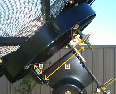
Look at the picture below.
...
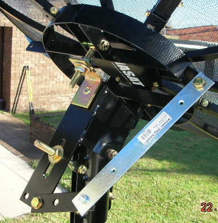
I have marked three distances A, B and C. Note the "Downward tilt" screw adjuster near C. This screw needs lengthening so that the top of the dish tilts forwards a little.

Measure A and B

Do this calculation

C = B x tan(4.6) + A
C= B x 0.08 + A

to find out what distance C should be and then adjust the screw till C is the correct distance. Distance C will be larger than distance A. When setting distance C, note that the distance includes the thickness of the L shaped bracket.

There are several further steps (which I will write about more here in due course):

2. Setting the main polar axis angle (angle measurement and adjustment, you might make an inclinometer https://www.satsig.net/pointing/how-to-make-inclinometer.htm)
...
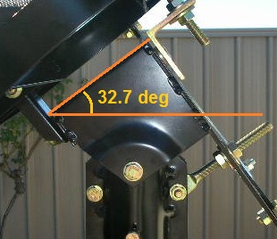
This image shows the main axis angle set up. At present your angle is about 37 deg. You need to adjust it to 32.7 deg.

Applying the inclinometer will enable the angle to be set.

3. Setting the whole mount centered to aim at due north.
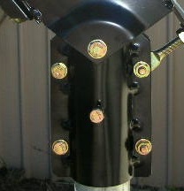
In this image below loosen slightly the 4 bolts holding the clamp to the pole.
...

Also adjust, if necessary, the sideways adjuster (long silver strip) so that the mechanism is centered with the dish pointed at its highest angle. You are already either at this position of very close to it, so no adjustment may be needed.
...

The task now is to rotate the entire mount (via the pole clamp) so it is aimed true north.
Look in Lyngsat and find a suitable satellite that is almost due north of you. (on same longitude at your site). In your case your wanted satellite at 113 deg east is sufficiently close to your longitude so use this satellite for alignment purposes.

Put the satellite position into the calculator and also your location.

A motor drive sideways angle will be given.

Polar mounts only: Main angle= 32.7, Downward tilt= 4.6, Motor drive sideways angle= -3.3

Lengthen the silver strip so that the antenna is 3.3 deg to the left of central.

Now peak up on your wanted satellite using the pole clamp. Tighten the pole clamp.

4. All satellites should now be visible as you swing the dish, using the silver strip, boldly all the way from side to side.

Warning: The above instructions sound straightforward but be warned that many people take several days to get it right.
wxw
Best regards, Eric.
Back to top
« Last Edit: Jan 31st, 2020 at 1:23pm by Admin1 »  
 
IP Logged
 
Bejo
Member
★★
Offline


Posts: 3
Australia
Reply #21 - May 22nd, 2012 at 11:15am  

Thanks again Eric,

Already adjust the C distance that's 5.63 cm includes the thickness of L shaped bracket.
Adjust the main angle to 32.7 degree and try to BLIND SCAN and still could not find TV or Radio channel, try a little bit up/down but same result.
My longitude is 115.89 E, located in Perth.

You previously mentioned a very simple satellite pointing meter. Where to buy this apparatus and what brand?

I will try to move around that figure and hope to get at least one satellite.

Regards,

Heru
Back to top
 

Bejo-Aussie
 
IP Logged
 
Eric Johnston
Senior Member
★★★
Offline


Posts: 2109
Reply #22 - May 22nd, 2012 at 11:52am  
Satellite TV shops sell inexpensive satellite TV meters (e.g. 15$) that simply measure noise power from the LNB. They give an indication on any and all satellites and help peak up. Example: https://www.sadoun.com/Sat/Products/Accessories/Meters/SF95L-DSS-FTA-Satellite-S...

Your receiver may have a similar display option. Once you see a decent amount of power, then activate the tuning scan to see what is on that satellite.

Tweeking the angles will almost certainly be necessary to peak up.

Best regards, Eric.
Back to top
« Last Edit: Jan 31st, 2020 at 1:24pm by Admin1 »  
 
IP Logged
 
Bejo
Member
★★
Offline


Posts: 3
Australia
Reply #23 - May 23rd, 2012 at 12:02pm  

Dear Eric,

I 've got what I want ! You are great help. Thank you.
Your explanation is very detail, so it is easy to follow.

I'm thinking to add another LNB next time

Thank you very much,

Regards,
Bejo
Back to top
 

Bejo-Aussie
 
IP Logged
 
sjayaraj7
Member
★★
Offline


Posts: 2
Reply #24 - Jun 7th, 2012 at 9:56am  
hi.
im not sure sure about lnb skew for my cband single lnb.
how do i set it up?
i have the azimuth and elevation for my dish already.
Back to top
 
 
IP Logged
 
SuperDave
Member
★★
Offline


Posts: 18
Reply #25 - Jun 7th, 2012 at 1:32pm  
sjayaraj7,  You can go to https://www.satbeams.com/satellites and click the link to the satellite your using and the icon for your beam (C-band in your case).
Then zoom in on the map to your location and click on the map to place an icon at your site, on the left side of the webpage you will see your look angles and your LNB skew angle.

Hope this info is what your looking for!
Back to top
 

Dave
 
IP Logged
 
Pages: 1