|
|
Home > Miscellaneous > Sailing > Clipper 2015-2016 Virtual race index > Hobart race to Whitsundays- Leg 6
Clipper 1516: Hobart to Whitsundays: Leg 6
This page refers to the Virtual Clipper round the world sailing race game and the log of the BRITPACK 7 team.
The start is 01:30 GMT Saturday 2nd Jan 2016. Approx 1600 miles, 8 days
To join in the race game go to Virtual Regatta (external link) and invent your boat. Its free of charge for a boat with basic sails and manual steering. You can pay for options: faster pro sails, a route waypoints programming capability and automatic locking of the wind angle. Boats with options are called AO (avec options). Boats without options are called SO (sans options). In the team competition the scores for SO and AO boats are adjusted to compensate for the difference. Obviously, in the main individual boats race, an AO boat does better and has more chance of winning a prize. The number of competitors is now over 40170.
Our Britpack 7 team comprises 8 boats, the first 5 of which will score in each race. We need more boats volunteered on standby, in case someone wants a rest, drops out or does not start. Email me eric@satsig.net
Our team now comprises:
Aberlady
Mullionman
Beowulf 1
Minzpint
Kames Bay
satsig.net
Lady Phyllis May
Flambouyant
Welcome to Kames Bay who joins the team.
If you wonder why the destination is called Whitsunday I believe it is because the passage between the islands of the beautiful Great Barrier Reef and the mainland was discovered by captain Cook on Whitsunday !
In preparation for the start of this leg 6, watch this video :
Watch a video below showing Clipper 70's participating the Sydney to Hobart race 2015:
https://www.youtube.com/watch?v=CI8_In35oO0
In the recent previous races the following boats (all sans options SO, like us) in Team TMSO have done well. It might be an idea to add them to your screen display:
taberly-AVL
kaechon camp 14
Pamela 75-EZ
RIC49
biorne
tame bird
JFLBJFLB
pirate_d_aghmat
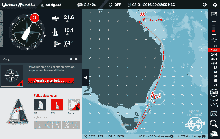
Here is guesstimate of the route and time of arrival at the finish:
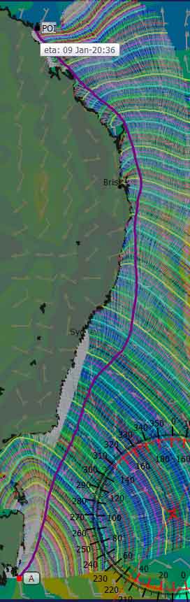
Don't be misled into thinking it looks straightforward. There are going to be big problems navigating amongst all the Great Barrier Reef islands. The start on this chart is off to the west round the southern tip and assumes 4 hours getting there from the actual start, as my route planning qtvlm software could not cope with getting out south of Hobart and then turning the corner. It kept trying to go north via the land of Tasmania immediately from the start.
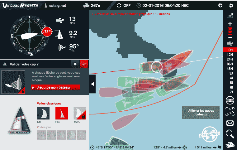
Shortly after the start this shows the boats preparing to turn north into the Pacific Ocean. I tried to get though the narrow creek without a paddle but failed and got held up by 20 minutes. The AO boats with waypoints managed the creek successfully, a point worth noting for 2018. Anyway 267th is my best placing ever, even if it was for only 10 minutes. Lost over 1000 places !
Now set off into the blue. I went north with highest boat speed thinking that I would gain back a few places which I did but then realised that I would do better in the long run if I west east hoping for stronger winds over next several days.
Now I've lost even more places, partly due to trying to drift gradually east and partly due to the far west boats gaining in terms of distance north. They may have problems due to light winds later.
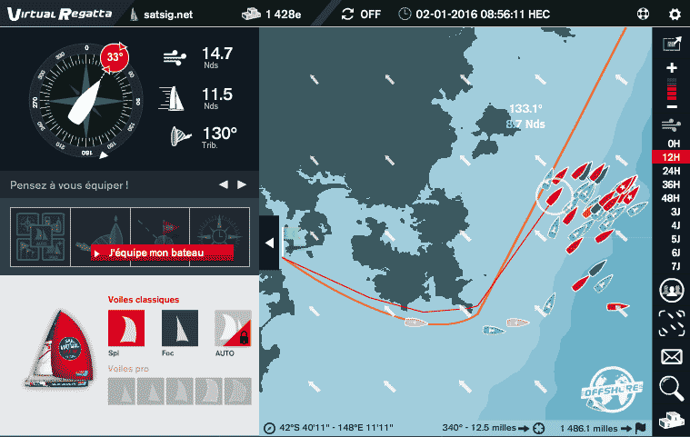
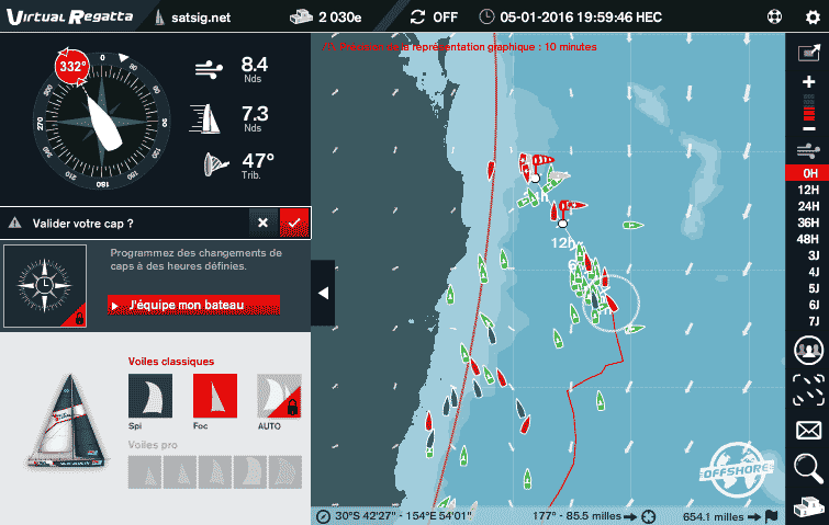
19:22G 3rd Jan: Minzapint, far to the west (near the edge of the white circle) and Beowulf 1, about half way, are both 20 miles ahead of me. I'm still hoping for some benefit from stronger winds.
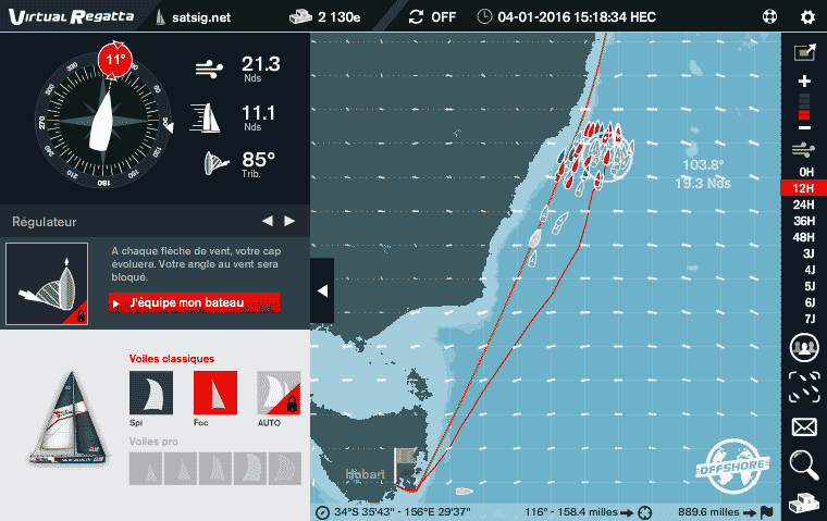
14:18G 4th Jan.
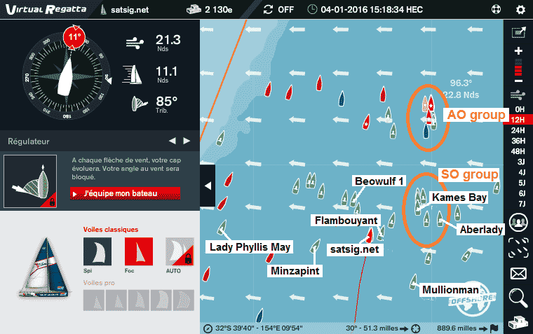
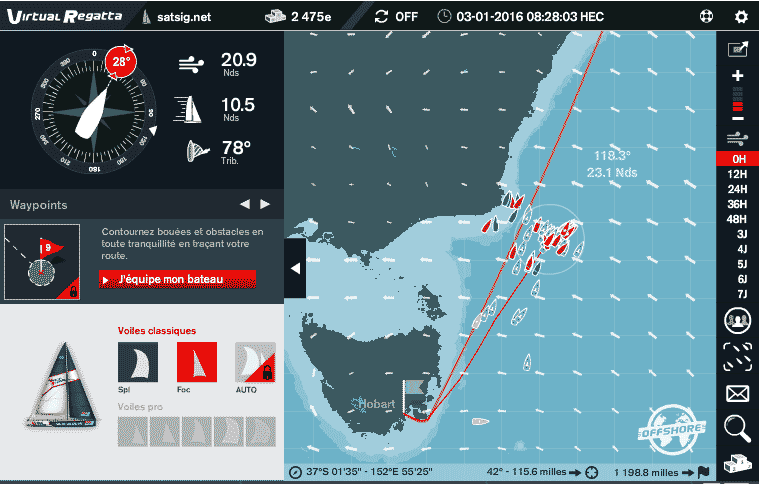
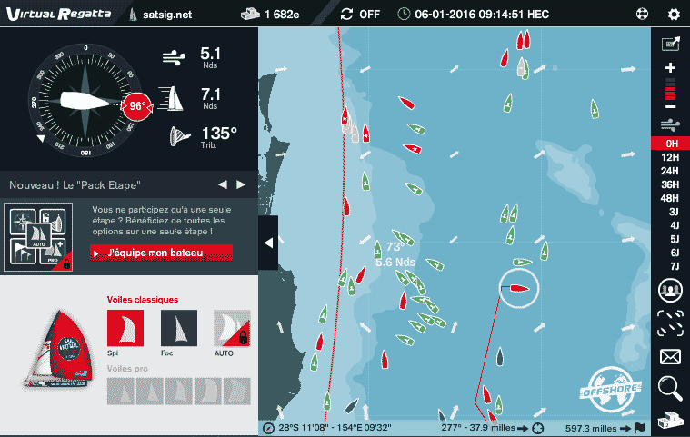
14:18G 4th Jan, same as above, but showing the details. The AO group with pro sails are leading by about 30 miles, or half a degree in latitude. Out three leading boats are Beowulf 1, Kames Bay and Aberlady, presently in 1149th, 1416th and 1765th positions. The SO group have done well today going north along a ridge of stronger winds, with lighter winds to both the west and east. 41941 competitors but how many actually participating in this leg ? My guess 13000.
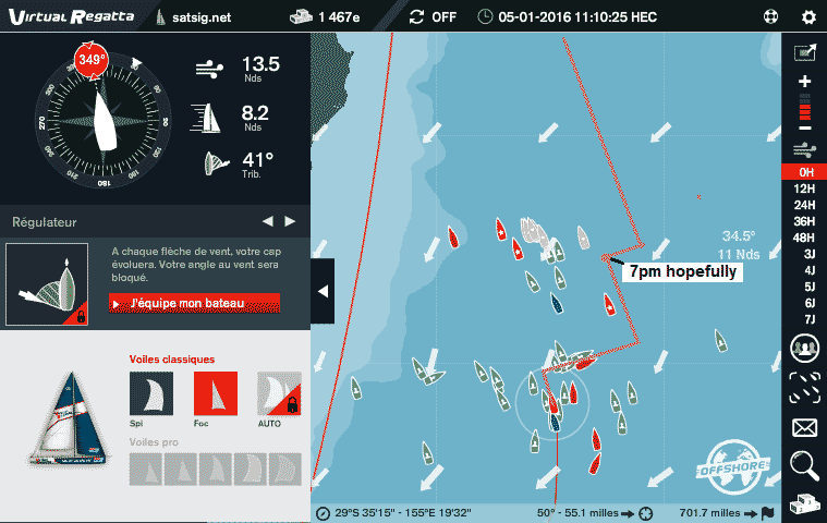
5th Jan 10:10am GMT. This morning the wind changed so it was coming from north east and made everyone stop unless they turned immediately to the north west, see above. All is now going well, keeping a wind angle like 45 deg, but even then there is a tendency later on to be forced too far west into light winds, so my plan is as shown with orange line, tacking in about an hour and then later at about 2pm for a 5 hour beat to the north west, prior to 7pm. The weather forecast update comes about 5pm so that will affect options.
I went too far sideways to the east and lost a lot of places,
The wind right ahead is going in opposite directions, a sign of very low wind strengths in the middle so I am going sideways, which is often a bad idea.
Interesting to see how some boats managed to negotiate the narrow route inside between the mainland and the Fraser Island. Looking at a real map the route does not look feasible for a real boat. This is the "Sunshine Coast" about 100 miles north of Brisbane.
With the finish more or less in sight, 85 miles to go, I'm not too fast out to sea and unable to get in without either going too close to downwind (more than 145 wind angle) or gybing. No idea what is best.
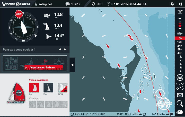
8th Jan 16:06 GMT. Wondering where to go?. If I stay out along the red line I avoid light winds close in to the coast between 10pm and 2am tonight. With a bit of luck will be finished by 7am tomorrow morning. A similar strategy course suggested for Minzapint. Yet another option ! See yellow line added at 10:30pm. About the same distances involved, but stronger winds all the way. And a third option, the pink route is shortest with fast winds but involves steering through a narrow gap at high speed. Not for me, once bitten twice shy!
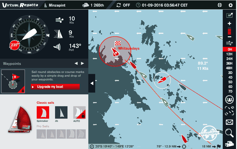
9th Jan: It's 2:56am and I'm on board Minzapint. The red line shows the track followed. During the last half hour I drew the line for the new gybe bearing and waited till the last moment to turn left, since the winds further out were stronger and it made sense to stay out. During the south east movement the distance to the finish changes little and I am losing places at the rate of about 25 per 10 minutes.
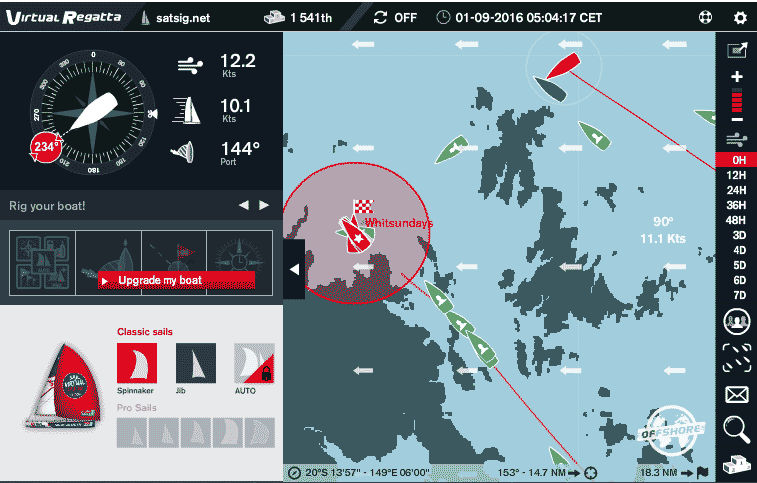
9th Jan: It's 4:04am and I back aboard satsig.net and have just turned left aiming to get between the gap in the islands. At the gap I was able to make a 2 deg left adjustment and further on at the next tiny reef I turned left a further 3 deg to maximise speed and get the wind angle down towards 130 deg, towards the finish. The finish is a circle and I crossed just to the south if the direct shortest route
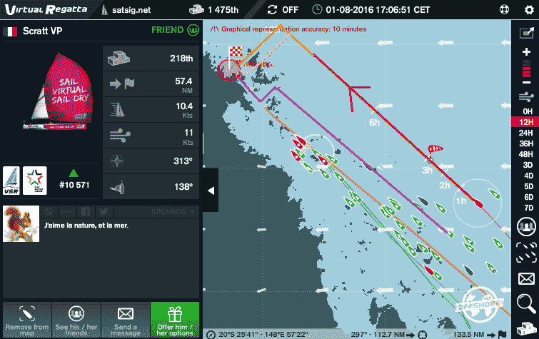
Flambouyant made a heroic effort to get there, passing through the narrow gap marked in pink on the 3rd chart further up this page. As per my previous experience, and others, it is difficult to navigate narrow twisting channels, a few hundred yards wide, when the boat goes in increments, each a straight line of 1.5miles distance.
Results, with the first 5 to score in the overall teams competition:
1st Mullionman 884
2nd Aberlady 1040
3rd Minzapint 1191
4th Beowulf 1 1245
5th satsig.net 1366
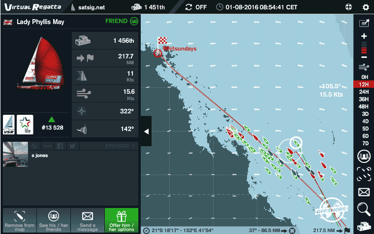
6th Lady Phyllis May 1860
7th Flambouyant 2008
8th Kames Bay 2863
Wondering how the real Clipper 70 yachts boats got on through all the tiny islands of the Great Barrier Reef this map below shows the Clipper 70 race status around midday today.
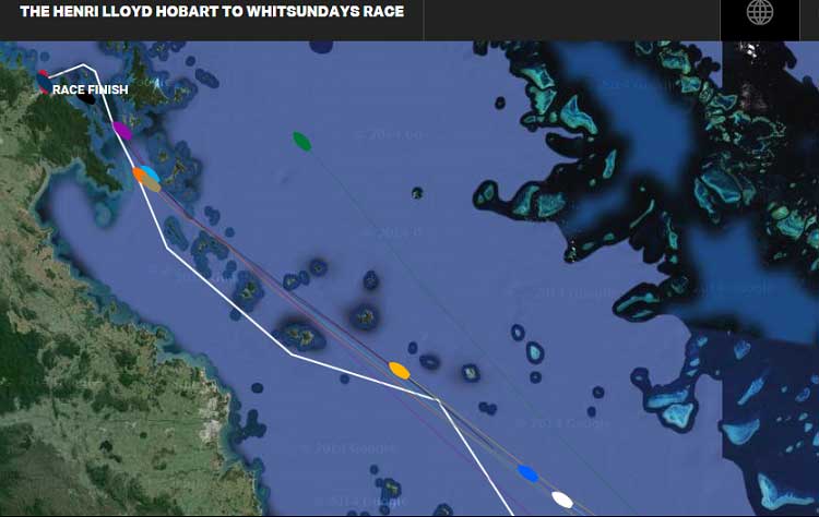
L MAX EXCHANGE in red and GREAT BRITAIN in dark blue have finished. Purple is DERRY-LONDONDERRY-DOIRE, Orange is DA NANG - VIET NAM, light blue is UNICEF and grey is ICHORCOAL. Yellow is QINGDAO, bright blue is PSP LOGISTICS and white is VISIT SEATTLE. The boat far out to sea in green is CLIPPERTELEMED+. I think they have chosen the safest route. Maybe their GPS is not working.
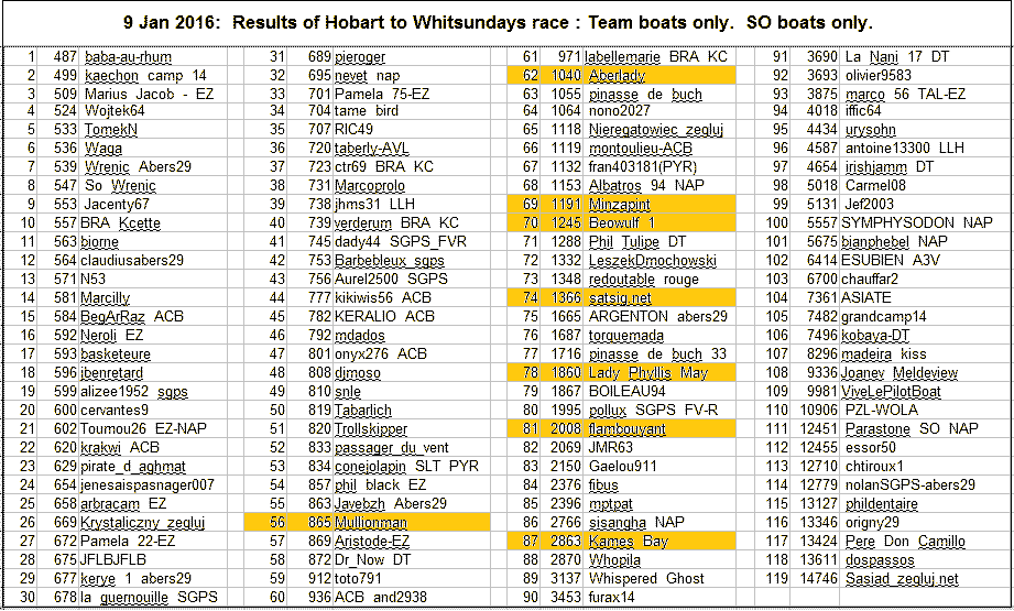
These results for race 6 apply to SO team boats. It is recommended that you consider putting the top boats on your screens.
BRITPACK 7 Team log for the next race will continue on a new web page.
Next race 7: Monday 18th Jan 2016, START 07:00 GMT, from Airlie Beach to Da Nang. Finish (estimated) 17th - 21st Feb
Check the Virtual Regatta site nearer the time. On the last race there was only 24 hrs notice of the start time.
If you want to add comment or images here please send to me by email: eric@satsig.net
|
Page created 1st January 2016, amended 9 June 2021 ECJ (c) 2016 Copyright Satellite Signals Limited, All rights reserved. |